IMAGES TAKEN NEAR TO
Lulach Court, DUNFERMLINE, KY11 8HJ
Introduction
This page details the photographs taken nearby to Lulach Court, KY11 8HJ by members of the Geograph project.
The Geograph project started in 2005 with the aim of publishing, organising and preserving representative images for every square kilometre of Great Britain, Ireland and the Isle of Man.

There are currently over 7.5m images from over14,400 individuals and you can help contribute to the project by visiting https://www.geograph.org.uk
Image Map
Images are licensed for reuse under creativecommons.org/licenses/by-sa/2.0
Notes
- Clicking on the map will re-center to the selected point.
- The higher the marker number, the further away the image location is from the centre of the postcode.
Image Listing (14 Images Found)
Images are licensed for reuse under creativecommons.org/licenses/by-sa/2.0
Image
Details
Distance
1
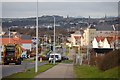
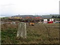
Dunfermline
The eastward expansion of Dunfermline has transformed the road from Dunfermline to Aberdour (B916) from being a fairly quiet country road to a busy urban thoroughfare. The view is towards Dunfermline.
Image: © Paul McIlroy
Taken: 28 Jan 2007
0.09 miles
2
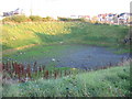
Drainage Pond
A rare sight - a dry drainage pond!
Image: © Robert Struthers
Taken: 5 Nov 2007
0.11 miles
3
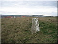
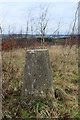
Dover Heights
The triangulation pillar, visited in the early days of housing development here. Access was awkward at the time, but now (2019) this is an informal open space and visiting the pillar is easy.
Image: © Richard Webb
Taken: 29 Mar 2004
0.19 miles
4
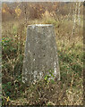
Dover Heights Trig Point Flush Bracket S4412
Image: © thejackrustles
Taken: 21 Nov 2015
0.19 miles
5
Dover Heights Dunfermline
Triangulation pillar on common land at Dover Heights.
Image: © edward mcmaihin
Taken: 31 Jan 2014
0.19 miles
6
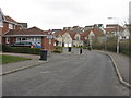
New housing at Dover Drive
Leading to Dover Heights, open land not so long ago.
Image: © M J Richardson
Taken: 25 Mar 2013
0.20 miles
7
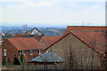
Dover Heights Dunfermline
Viewed looking west towards Rosyth from the triangulation pillar.
Image: © edward mcmaihin
Taken: 31 Jan 2014
0.20 miles
8
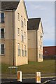
Tarmachan road Dunfermline
Housing at Tarmachan road Dunfermline.
Image: © edward mcmaihin
Taken: 16 Feb 2010
0.22 miles
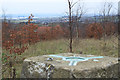
9
Dovers Heights, Duloch
Hill top with view of the Forth Bridges. The area around the trig pillar has been planted with trees, this is to be the centrepiece of two housing developments, either side of the hill. Construction work is taking place nearby.
A vast area of once rural land between Dunfermline and the M90 is now being developed for housing and industry. The name Duloch, formerly a farm, has become familiar, appearing on new road signs and new access roads have been built, all with many roundabouts.
Image: © Richard Webb
Taken: 29 Mar 2004
0.22 miles
10
Dover Heights Dunfermline
Viewed from Dover Heights over the new housing towards the Forth Bridges.
Image: © edward mcmaihin
Taken: 31 Jan 2014
0.22 miles