IMAGES TAKEN NEAR TO
Holly Crescent, DUNFERMLINE, KY11 8BY
Introduction
This page details the photographs taken nearby to Holly Crescent, KY11 8BY by members of the Geograph project.
The Geograph project started in 2005 with the aim of publishing, organising and preserving representative images for every square kilometre of Great Britain, Ireland and the Isle of Man.

There are currently over 7.5m images from over14,400 individuals and you can help contribute to the project by visiting https://www.geograph.org.uk
Image Map
Images are licensed for reuse under creativecommons.org/licenses/by-sa/2.0
Notes
- Clicking on the map will re-center to the selected point.
- The higher the marker number, the further away the image location is from the centre of the postcode.
Image Listing (8 Images Found)
Images are licensed for reuse under creativecommons.org/licenses/by-sa/2.0
Image
Details
Distance
1
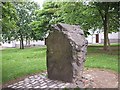
Pitcorthie Standing Stone
This Standing Stone is right in the middle of the housing estate of Pitcorthie Dunfermline.
Image: © Michael Murray
Taken: 5 Jun 2007
0.11 miles
2
Oak Grove, Dunfermline.
Oak Grove, Pitcorthie, Dunfermline.
Image: © edward mcmaihin
Taken: 21 May 2010
0.12 miles
3
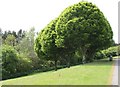
Trees at Pitcorthie
Trees at the side of the footpath on the southside of Pitcorthie.
Image: © edward mcmaihin
Taken: 21 May 2010
0.13 miles
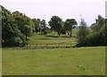
4
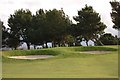
Golf Course
A double bunker on Pitreavie Golf Course.
Image: © Paul McIlroy
Taken: 16 Mar 2007
0.16 miles
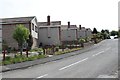
5
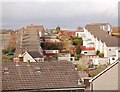
Housing
This is a part of Pitcorthie housing estate on south side of Dunfermline.
Image: © Paul McIlroy
Taken: 16 Mar 2007
0.17 miles
6
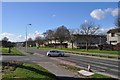
Aberdour Road
Looking west along Aberdour Road
Image: © Robert Struthers
Taken: 3 Apr 2011
0.18 miles
7
Pitreavie Golf Course, Dunfermline.
Golf course viewed from the footpath at Pitcorthie.
Image: © edward mcmaihin
Taken: 21 May 2010
0.18 miles
8
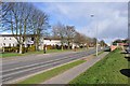
Aberdour Road
Looking east along Aberdour Road.
Image: © Robert Struthers
Taken: 3 Apr 2011
0.25 miles