IMAGES TAKEN NEAR TO
Cedar Grove, DUNFERMLINE, KY11 8BH
Introduction
This page details the photographs taken nearby to Cedar Grove, KY11 8BH by members of the Geograph project.
The Geograph project started in 2005 with the aim of publishing, organising and preserving representative images for every square kilometre of Great Britain, Ireland and the Isle of Man.

There are currently over 7.5m images from over14,400 individuals and you can help contribute to the project by visiting https://www.geograph.org.uk
Image Map
Images are licensed for reuse under creativecommons.org/licenses/by-sa/2.0
Notes
- Clicking on the map will re-center to the selected point.
- The higher the marker number, the further away the image location is from the centre of the postcode.
Image Listing (8 Images Found)
Images are licensed for reuse under creativecommons.org/licenses/by-sa/2.0
Image
Details
Distance
1
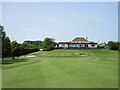
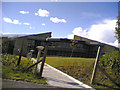
Pitreavie Golf Club, 18th Hole, Home
The final hole at Pitreavie looking up to the two-tiered green with the clubhouse beyond.
Image: © Scott Cormie
Taken: 31 Jul 2024
0.08 miles
2
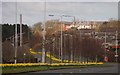
Dual Carriageway
This is a view of the Dunfermline to Rosyth dual carriageway (A823) which is said to be the first road of this type in Scotland. When the Dunfermline Tramway was extended in 1918 to include a route to Rosyth Dockyard the road was reconstructed to accommodate the tramlines running in the central area between two carriageways. This view is towards Dunfermline, the area filled with daffodils is where the tram lines ran.
Image: © Paul McIlroy
Taken: 3 Apr 2007
0.09 miles
3
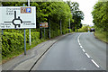
A823, Queensferry Road, Towards Dunfermline
Image: © David Dixon
Taken: 23 May 2017
0.11 miles
4
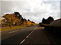
A823 dual carriageway at Pitcorthie, Dunfermline
Image: © Douglas Nelson
Taken: 22 Oct 2016
0.16 miles
5
Pop goes the Weasel
That's the way the money goes.....mostly these days, it would seem, via credit and debit card transactions.
Well for those of you who have a Visa Card. This is HBOS (Bank of Scotland) retail card processing centre.
St Margaret's Stone was moved from its original site here to make way for the roundabout. It's not moved far though and you can still see it, out of shot of this pic, to the left. Image]
HBOS http://en.wikipedia.org/wiki/HBOS was rescued from near collapse by Lloyds TSB http://en.wikipedia.org/wiki/Lloyds_Banking_Group in September 2008 which was itself rescued by the UK taxpayer by becoming largely nationalised the following month. HM Treasury own around 65% of the group.
Directly across the road... More weasels popping: http://www.geograph.org.uk/photo/42988
Image: © Simon Johnston
Taken: 25 Aug 2005
0.16 miles
6
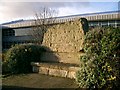
Saint Margaret's Stone.
Tradition has it that St. Margaret, later Queen to Malcolm Canmore, rested on this stone on her way to Dunfermline in 1069. The stone has been re sited many times.It now sits in front of this Call Centre.
Image: © Paul McIlroy
Taken: 16 Nov 2005
0.16 miles
7
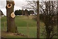
Golf Course
The tree surgeons have been busy here at Pitreavie Golf Course.
Image: © Paul McIlroy
Taken: 16 Mar 2007
0.19 miles
8
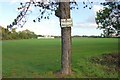
Pitreavie Playing Fields
Run by the local council these playing fields are on the south side of Dunfermline,the white building, which is in the next square, is the pavilion.
Image: © Paul McIlroy
Taken: 9 Oct 2006
0.22 miles