IMAGES TAKEN NEAR TO
Spruce Grove, DUNFERMLINE, KY11 8AE
Introduction
This page details the photographs taken nearby to Spruce Grove, KY11 8AE by members of the Geograph project.
The Geograph project started in 2005 with the aim of publishing, organising and preserving representative images for every square kilometre of Great Britain, Ireland and the Isle of Man.

There are currently over 7.5m images from over14,400 individuals and you can help contribute to the project by visiting https://www.geograph.org.uk
Image Map
Images are licensed for reuse under creativecommons.org/licenses/by-sa/2.0
Notes
- Clicking on the map will re-center to the selected point.
- The higher the marker number, the further away the image location is from the centre of the postcode.
Image Listing (6 Images Found)
Images are licensed for reuse under creativecommons.org/licenses/by-sa/2.0
Image
Details
Distance
1
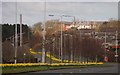
Dual Carriageway
This is a view of the Dunfermline to Rosyth dual carriageway (A823) which is said to be the first road of this type in Scotland. When the Dunfermline Tramway was extended in 1918 to include a route to Rosyth Dockyard the road was reconstructed to accommodate the tramlines running in the central area between two carriageways. This view is towards Dunfermline, the area filled with daffodils is where the tram lines ran.
Image: © Paul McIlroy
Taken: 3 Apr 2007
0.12 miles
2
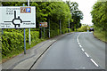
A823, Queensferry Road, Towards Dunfermline
Image: © David Dixon
Taken: 23 May 2017
0.14 miles
3
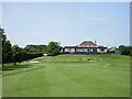
Pitreavie Golf Club, 18th Hole, Home
The final hole at Pitreavie looking up to the two-tiered green with the clubhouse beyond.
Image: © Scott Cormie
Taken: 31 Jul 2024
0.19 miles
5
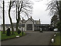
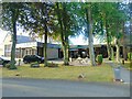
Pitbauchlie House Hotel
On the B916 Aberdour Road in Dunfermline.
Image: © M J Richardson
Taken: 25 Mar 2013
0.22 miles
6
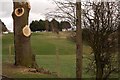
Golf Course
The tree surgeons have been busy here at Pitreavie Golf Course.
Image: © Paul McIlroy
Taken: 16 Mar 2007
0.23 miles