IMAGES TAKEN NEAR TO
Cochrane Walk, DUNFERMLINE, KY11 4XY
Introduction
This page details the photographs taken nearby to Cochrane Walk, KY11 4XY by members of the Geograph project.
The Geograph project started in 2005 with the aim of publishing, organising and preserving representative images for every square kilometre of Great Britain, Ireland and the Isle of Man.

There are currently over 7.5m images from over14,400 individuals and you can help contribute to the project by visiting https://www.geograph.org.uk
Image Map
Images are licensed for reuse under creativecommons.org/licenses/by-sa/2.0
Notes
- Clicking on the map will re-center to the selected point.
- The higher the marker number, the further away the image location is from the centre of the postcode.
Image Listing (19 Images Found)
Images are licensed for reuse under creativecommons.org/licenses/by-sa/2.0
Image
Details
Distance
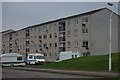
1
Bute Crescent
Empty block of flats awaiting renovation or demolition.
Image: © Paul McIlroy
Taken: 15 Dec 2005
0.05 miles
2
Housing
These flats are at Abel Place in the Touch (pronounced took) Estate on the east side of Dunfermline. The estate was built in the early 1970s and is mostly blocks of flats, although there are some houses.
Image: © Paul McIlroy
Taken: 4 Feb 2007
0.12 miles
3
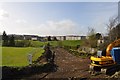
Groundbreaking
Preparing to lay new water pipes.
Image: © Robert Struthers
Taken: 4 Apr 2011
0.15 miles
4
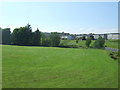
Playing fields, St Columba's Roman Catholic High School, Dunfermline
Image: © JThomas
Taken: 25 May 2017
0.16 miles
5
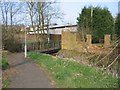
Footbridge over the Lyne Burn
Ubiquitous shopping trolley just visible! The white building in the centre is a scout hall.
Image: © Robert Struthers
Taken: 23 Mar 2012
0.17 miles
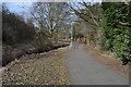
6

Footpath at the Lyne Burn
Looking north with the houses of Linburn Grove in the distance.
Image: © Robert Struthers
Taken: 23 Mar 2012
0.18 miles
8
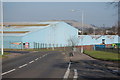
Factory near Garvock Hill
Former engineering works on the eastern side of Dunfermline
Image: © Paul Mc Ilroy
Taken: 18 Mar 2009
0.20 miles
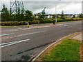
10
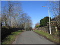
Old Linburn Road
Part of the original road which ran south from the junction with Halbeath Road towards Masterton.
Image: © Robert Struthers
Taken: 8 Mar 2005
0.22 miles