IMAGES TAKEN NEAR TO
Halbeath Retail Park, DUNFERMLINE, KY11 4LR
Introduction
This page details the photographs taken nearby to Halbeath Retail Park, KY11 4LR by members of the Geograph project.
The Geograph project started in 2005 with the aim of publishing, organising and preserving representative images for every square kilometre of Great Britain, Ireland and the Isle of Man.

There are currently over 7.5m images from over14,400 individuals and you can help contribute to the project by visiting https://www.geograph.org.uk
Image Map
Images are licensed for reuse under creativecommons.org/licenses/by-sa/2.0
Notes
- Clicking on the map will re-center to the selected point.
- The higher the marker number, the further away the image location is from the centre of the postcode.
Image Listing (28 Images Found)
Images are licensed for reuse under creativecommons.org/licenses/by-sa/2.0
Image
Details
Distance
2
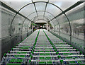
Shopping trolleys, Asda
Shopping trolleys at ASDA in Dunfermline - hinting at the scale of retailing at a large supermarket. This is just one of several trolley stations at the Dunfermline store.
Image: © William Starkey
Taken: 23 May 2011
0.05 miles
3
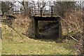
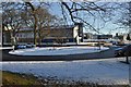
Old Railway Bridge
The Townhill railway, part of the mineral railway network which served the various collieries of West Fife, joined the main Fife Circle line just off to the right of the picture. The line closed in 1976. This bridge allowed access for farmers to get from one field to another, but with the post-closure lifting of the line it is no longer required, and the far side is overgrown and filled with debris.
Image: © Robert Struthers
Taken: 27 Feb 2016
0.09 miles
4
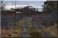
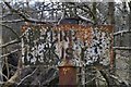
This Far and No Further
Beyond these gates is railway property, probably a depot of some sort. The road is part of the old Townhill Tram Road; there are two lengths of metal just visible under the gates, but it is unlikely that they are the remains of rails.
Image: © Robert Struthers
Taken: 27 Feb 2016
0.09 miles
5
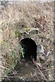
Buckie Burn Culvert
The Buckie Burn flows into this culvert. It then passes under the Fife Circle railway line and at some point emerges as part of the Lyne Burn.
Image: © Robert Struthers
Taken: 27 Feb 2016
0.10 miles
6
Old Railway Bridge
This is a view over the top of the disused bridge shown in Image, part of the Townhill railway. On the other side can be seen the boundary fence beyond which is the Fife Circle main line. The bridge is in a rather crumbling condition and I decided not to explore any further.
Image: © Robert Struthers
Taken: 27 Feb 2016
0.10 miles
7
Rusting Railway Relic
An identification sign on the former Townhill railway line.
Image: © Robert Struthers
Taken: 27 Feb 2016
0.10 miles
8
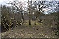
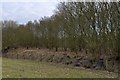
Townhill Railway Track Bed
The track bed of the Townhill railway line, closed in 1976. The line of the railway curved round to the left, doubling back towards Townhill. On the right is the present boundary fence of the Fife Circle railway line.
Image: © Robert Struthers
Taken: 27 Feb 2016
0.12 miles
9
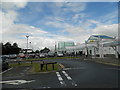
Roundabout and Holiday Inn Express
The busy roundabout on the A907 into Dunfermline.
Image: © Robert Struthers
Taken: 20 Jan 2018
0.14 miles
10
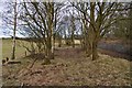
Former Railway Sidings
This copse of trees covers what used to be railway sidings on the Fife Circle line.
Image: © Robert Struthers
Taken: 27 Feb 2016
0.15 miles