IMAGES TAKEN NEAR TO
Shields Road, DUNFERMLINE, KY11 4DZ
Introduction
This page details the photographs taken nearby to Shields Road, KY11 4DZ by members of the Geograph project.
The Geograph project started in 2005 with the aim of publishing, organising and preserving representative images for every square kilometre of Great Britain, Ireland and the Isle of Man.

There are currently over 7.5m images from over14,400 individuals and you can help contribute to the project by visiting https://www.geograph.org.uk
Image Map
Images are licensed for reuse under creativecommons.org/licenses/by-sa/2.0
Notes
- Clicking on the map will re-center to the selected point.
- The higher the marker number, the further away the image location is from the centre of the postcode.
Image Listing (7 Images Found)
Images are licensed for reuse under creativecommons.org/licenses/by-sa/2.0
Image
Details
Distance
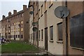
1
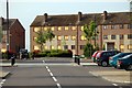
Flats in Abbeyview (2)
Boarded up flats awaiting renovation or demolition
Image: © Paul McIlroy
Taken: 21 Jun 2008
0.14 miles
2
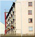
Flats at Abbeyview
This 1960s block of flats is undergoing renovation
Image: © Paul McIlroy
Taken: 21 Jun 2008
0.14 miles
3
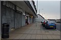
Shops
In Abbeyview housing estate, some of the shops are closed permanently, the only one opened today is the betting shop.
Image: © Paul McIlroy
Taken: 4 Feb 2007
0.14 miles
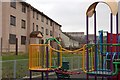
4

Play area
New play equipment in the Abbeyview area
Image: © Paul McIlroy
Taken: 21 Jun 2008
0.15 miles
5
Play area
Children's play area with a backdrop of derelict flats at Bute Crescent.
Image: © Paul McIlroy
Taken: 4 Feb 2007
0.17 miles
6
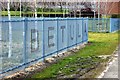
Protective fence
This fence is here to protect these young trees from vandals and predators. The species name is etched on the fence.
Image: © Paul McIlroy
Taken: 5 Apr 2008
0.17 miles
7
Allan Crescent
These boarded up flats are at Allan Crescent in Abbeyview Estate, they await a decision on their future.
Image: © Paul McIlroy
Taken: 4 Feb 2007
0.21 miles