IMAGES TAKEN NEAR TO
Sherbrooke Road, DUNFERMLINE, KY11 2YR
Introduction
This page details the photographs taken nearby to Sherbrooke Road, KY11 2YR by members of the Geograph project.
The Geograph project started in 2005 with the aim of publishing, organising and preserving representative images for every square kilometre of Great Britain, Ireland and the Isle of Man.

There are currently over 7.5m images from over14,400 individuals and you can help contribute to the project by visiting https://www.geograph.org.uk
Image Map
Images are licensed for reuse under creativecommons.org/licenses/by-sa/2.0
Notes
- Clicking on the map will re-center to the selected point.
- The higher the marker number, the further away the image location is from the centre of the postcode.
Image Listing (18 Images Found)
Images are licensed for reuse under creativecommons.org/licenses/by-sa/2.0
Image
Details
Distance
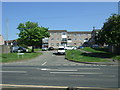
1
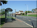
Bus stop and shelter on Castle Road, Rosyth
Image: © JThomas
Taken: 25 May 2017
0.07 miles
2
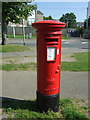
Elizabethan postbox on Castle Road, Rosyth
Showing position of George V Postbox No. KY11 167.
See Image] for context.
Image: © JThomas
Taken: 25 May 2017
0.07 miles
3
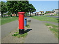
Path beside Castle Road, Rosyth
Showing position of Postbox No. KY11 167.
See Image] for postbox.
Image: © JThomas
Taken: 25 May 2017
0.07 miles
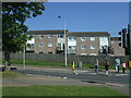

8
Rosyth Fire Station
Situated on Castle Road.
Image: © Paul McIlroy
Taken: 1 Apr 2006
0.14 miles
9
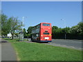
Bus stop and shelter on Castle Road, Rosyth
Image: © JThomas
Taken: 25 May 2017
0.15 miles
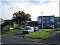
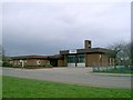
10

Rosyth old fire station
Rosyth old fire station, Castle Road, Rosyth, Dunfermline, Fife, closed in 2010 with the opening of the new Pitreavie fire station. See also Image
Image: © Kevin Hale
Taken: 2 Aug 2010
0.17 miles