IMAGES TAKEN NEAR TO
Lothians View, DUNFERMLINE, KY11 2UY
Introduction
This page details the photographs taken nearby to Lothians View, KY11 2UY by members of the Geograph project.
The Geograph project started in 2005 with the aim of publishing, organising and preserving representative images for every square kilometre of Great Britain, Ireland and the Isle of Man.

There are currently over 7.5m images from over14,400 individuals and you can help contribute to the project by visiting https://www.geograph.org.uk
Image Map
Images are licensed for reuse under creativecommons.org/licenses/by-sa/2.0
Notes
- Clicking on the map will re-center to the selected point.
- The higher the marker number, the further away the image location is from the centre of the postcode.
Image Listing (19 Images Found)
Images are licensed for reuse under creativecommons.org/licenses/by-sa/2.0
Image
Details
Distance
1
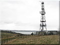
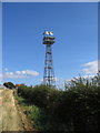
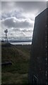
Radio mast at Castland Hill
Looking over towards the Firth of Forth. One of several masts on the hilltop which were originally, I believe, part of a naval wireless telegraph station from the early 1900s.
Image: © M J Richardson
Taken: 25 Mar 2013
0.04 miles
2
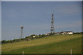
Masts on Castlandhill, Inverkeithing
Image: © Mike Pennington
Taken: 12 Jun 2015
0.04 miles
3
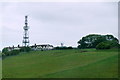
Comms tower on Castlandhill, North Queensferry
Image: © Mike Pennington
Taken: 2 Jun 2017
0.04 miles
4
A Mast, Pillbox and Tunnel Entrance on Castlandhill
There is a lot going on at the top of this hill - four tall masts, two covered reservoirs, a trig point, some well-appointed houses, at least two pillboxes, a zig-zagging short underground tunnel, a Pilgrim Way walking route, and some farmland!
The pillbox is on the right - there was once access to its base but this has since been blocked up. The hole at the bottom left of the picture is where some steps go down to a short tunnel that after seven 90° turns emerges by other steps right next to the mast on this same side. The slabs in the centre of the picture, which have what looks like a couple of fenceposts resting on them, indicate some of its course. I presume the tunnel was in some way linked to the pillbox.
Image: © Ian Dodds
Taken: 13 Mar 2021
0.06 miles
5
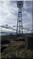
Communications Tower on Castlandhill
Image: © Robert Struthers
Taken: 7 Sep 2007
0.07 miles
6
Triangulation Pillar
Triangulation Pillar on Castlandhill reservoir.
Image: © Paul McIlroy
Taken: 10 Aug 2007
0.09 miles
7
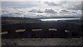
View from WWI Pillbox on Castlandhill
The most likely reason these are called pillboxes is also the most boring one! It is probably just a shortening of pillar box, another word for postbox. This is because the narrow slits, properly termed loopholes, through which if required, soldiers would fire their weapons, resemble the slots on postboxes.
This one is situated a short distance down the South slope of Castlandhill and didn't have any entrances, blocked up or otherwise, to its base as they sometimes do.
Image: © Ian Dodds
Taken: 13 Mar 2021
0.09 miles
8
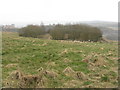
Circular wood at Castlandhill
One of two circular enclosures on Castlandhill, now containing trees but which, I believe, at one time may have contained communications equipment in connection with RAF Pitreavie or the naval Castlandhill Wireless Telegraph Station that was on the site from the early 1900s.
Image: © M J Richardson
Taken: 25 Mar 2013
0.09 miles
9
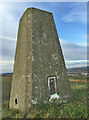
Castlandhill Reservoir Trig Point S3239
Image: © thejackrustles
Taken: 21 Nov 2015
0.10 miles
10
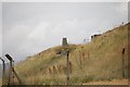
Castlandhill Trig Point
Officially called Castlandhill Reservoir trig point because it is, perhaps uniquely, positioned at the extreme corner of one of two covered reservoirs at the top of this hill. I have never before had to scale a tall fence in order to get to a trig point, but needs must!
The view is of the Firth of Forth and one of four tall masts that are located around the top of Castlandhill. The trig point was in official use from 1946.
Image: © Ian Dodds
Taken: 13 Mar 2021
0.12 miles