IMAGES TAKEN NEAR TO
Forker Avenue, DUNFERMLINE, KY11 2UF
Introduction
This page details the photographs taken nearby to Forker Avenue, KY11 2UF by members of the Geograph project.
The Geograph project started in 2005 with the aim of publishing, organising and preserving representative images for every square kilometre of Great Britain, Ireland and the Isle of Man.

There are currently over 7.5m images from over14,400 individuals and you can help contribute to the project by visiting https://www.geograph.org.uk
Image Map
Images are licensed for reuse under creativecommons.org/licenses/by-sa/2.0
Notes
- Clicking on the map will re-center to the selected point.
- The higher the marker number, the further away the image location is from the centre of the postcode.
Image Listing (17 Images Found)
Images are licensed for reuse under creativecommons.org/licenses/by-sa/2.0
Image
Details
Distance
1
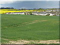
Rosyth housing estate
With no specific area name as far as I can see, but the Brankholm Burn runs in the depression between field and houses.
Image: © M J Richardson
Taken: 6 May 2012
0.03 miles
2
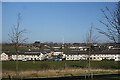
Housing Estate
Looking down from Unwin Avenue towards Forker Avenue and other blocks of modern terraced houses.
Image: © Anne Burgess
Taken: 1 Mar 2022
0.08 miles
3
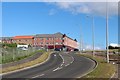
Houses at Rosyth
Looking northwards from Admiralty Road [A985].
Image: © M J Richardson
Taken: 6 May 2012
0.14 miles
4
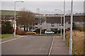
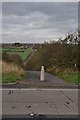
Brankholm Brae
Brankholm Brae runs from the A985 Rosyth to Kincardine road to Grange Road, a much used and dangerous shortcut to Dunfermline. Brankholm Brae is also as far west as housing development in Rosyth has been allowed to extend.
Image: © Paul McIlroy
Taken: 5 Mar 2007
0.16 miles
6
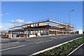
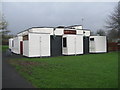
Supermarket Under Construction
The skeleton of a new supermarket on the outskirts of Dunfermline and Rosyth.
Image: © Robert Struthers
Taken: 4 Oct 2014
0.18 miles
7
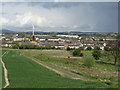
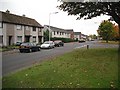
Housing
This is the Camdean housing estate, this part of it was built in the late 1960s. The towers of the Forth Road Bridge can be seen in the background.
Image: © Paul McIlroy
Taken: 5 Mar 2007
0.18 miles
8
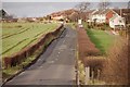
Primrose Avenue
Residential road. The references to Primrose in the area derive from a farm on Grange Road.
Image: © Richard Webb
Taken: 15 Oct 2009
0.19 miles
9
Old Road as Footpath
This footpath is on the original line of Grange Road, visible in the background, which now joins the main road a few hundred metres to the east.
Image: © Robert Struthers
Taken: 28 Oct 2011
0.21 miles
10
Cottars on Primrose Avenue
A rather functional looking pub at Rosyth.
Image: © M J Richardson
Taken: 4 Apr 2014
0.22 miles