IMAGES TAKEN NEAR TO
Wemyss Street, DUNFERMLINE, KY11 2JT
Introduction
This page details the photographs taken nearby to Wemyss Street, KY11 2JT by members of the Geograph project.
The Geograph project started in 2005 with the aim of publishing, organising and preserving representative images for every square kilometre of Great Britain, Ireland and the Isle of Man.

There are currently over 7.5m images from over14,400 individuals and you can help contribute to the project by visiting https://www.geograph.org.uk
Image Map
Images are licensed for reuse under creativecommons.org/licenses/by-sa/2.0
Notes
- Clicking on the map will re-center to the selected point.
- The higher the marker number, the further away the image location is from the centre of the postcode.
Image Listing (19 Images Found)
Images are licensed for reuse under creativecommons.org/licenses/by-sa/2.0
Image
Details
Distance
1
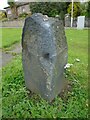
Old milestone
On Queensferry Road, Rosyth at the Park Road junction opposite the Godolphin Inn. The holes, one lead filled, show it once had a metal cap. Possibly an 18C/19C turnpike stone. The legend may have been NF 3 (North Ferry) on the left face and DUNF 3 (Dunfermiline) on the right.
Image: © Chris Minto
Taken: 15 Aug 2020
0.14 miles
2
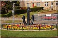
Flower bed and anchor
Situated at the corner of Park Road and Queensferry Road. The anchor is to acknowledge the naval connection to Rosyth.
Image: © Paul McIlroy
Taken: 17 Apr 2007
0.15 miles
3
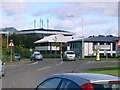
The Road to Dunfermline
This is the exit for Dunfermline (A823) off the Pitreavie Roundabout. The building in the background is the headquarters of The Dunfermline Building Society. A front view can be seen in square NT1185
Image: © Paul McIlroy
Taken: 29 Sep 2005
0.15 miles
5
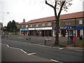
Shops, Queensferry Road
Row of shops on the corner with Park Road.
Image: © Richard Webb
Taken: 15 Oct 2009
0.16 miles
7
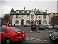
Palace, Rosyth
Former cinema. The Palace closed in 1971. Now a bar.
Image: © Richard Webb
Taken: 15 Oct 2009
0.18 miles
8
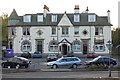
The Goth
The Gothenburg, just off Queensferry Road, Rosyth. A few years on from Image, the taxis and recycling bins are still there. Gothenburgs (Goths) appeared in the early 20th century as a cultural and community hub for industrial, usually mining communities. The pub would share some of its profits with the community for cultural and educational purposes. The model was imported from the Swedish city.
Image: © Richard Webb
Taken: 15 Oct 2009
0.18 miles
10
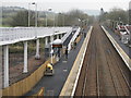
Looking east from Rosyth Station
Considerably modified since the earlier photos, taken in 2005 Image and 2008 Image, especially with the long ramp for disabled access. The builders are still on site. Looking from the Queensferry Road bridge over.
Image: © M J Richardson
Taken: 4 Apr 2014
0.18 miles