IMAGES TAKEN NEAR TO
Peasehill Road, DUNFERMLINE, KY11 2GA
Introduction
This page details the photographs taken nearby to Peasehill Road, KY11 2GA by members of the Geograph project.
The Geograph project started in 2005 with the aim of publishing, organising and preserving representative images for every square kilometre of Great Britain, Ireland and the Isle of Man.

There are currently over 7.5m images from over14,400 individuals and you can help contribute to the project by visiting https://www.geograph.org.uk
Image Map
Images are licensed for reuse under creativecommons.org/licenses/by-sa/2.0
Notes
- Clicking on the map will re-center to the selected point.
- The higher the marker number, the further away the image location is from the centre of the postcode.
Image Listing (16 Images Found)
Images are licensed for reuse under creativecommons.org/licenses/by-sa/2.0
Image
Details
Distance
1
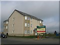
Fleet Recreation Ground
Not a sports facility anymore, now a housing development. Grid reference is of the triangulation pillar that was once here.
Image: © Richard Webb
Taken: 29 Mar 2004
0.05 miles
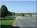
2
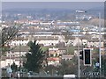
Rosyth
A view north towards Dunfermline.
Image: © Paul McIlroy
Taken: 1 Apr 2006
0.08 miles
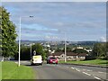
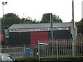
6

Rosyth old fire station
Rosyth old fire station, Castle Road, Rosyth, Dunfermline, Fife, closed in 2010 with the opening of the new Pitreavie fire station. See also Image
Image: © Kevin Hale
Taken: 2 Aug 2010
0.12 miles
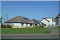
7

Recreation Park
Situated between Admiralty Road and Castle Road.
Image: © Paul McIlroy
Taken: 1 Apr 2006
0.12 miles
8

Rosyth Fire Station
Situated on Castle Road.
Image: © Paul McIlroy
Taken: 1 Apr 2006
0.14 miles
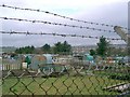
9
Entrance to Recreation Park, Rosyth
This is the entrance to the home ground of Rosyth Football Club.
Image: © Steve Barnes
Taken: 9 Aug 2010
0.18 miles
10
Allotments
At Kings Road next to Camdean Primary School,
Image: © Paul McIlroy
Taken: 1 Apr 2006
0.19 miles