IMAGES TAKEN NEAR TO
Spencerfield Road, INVERKEITHING, KY11 1QD
Introduction
This page details the photographs taken nearby to Spencerfield Road, KY11 1QD by members of the Geograph project.
The Geograph project started in 2005 with the aim of publishing, organising and preserving representative images for every square kilometre of Great Britain, Ireland and the Isle of Man.

There are currently over 7.5m images from over14,400 individuals and you can help contribute to the project by visiting https://www.geograph.org.uk
Image Map
Images are licensed for reuse under creativecommons.org/licenses/by-sa/2.0
Notes
- Clicking on the map will re-center to the selected point.
- The higher the marker number, the further away the image location is from the centre of the postcode.
Image Listing (28 Images Found)
Images are licensed for reuse under creativecommons.org/licenses/by-sa/2.0
Image
Details
Distance
1
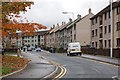
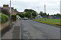
Inverkeithing/Fraser Avenue
Council housing built in the 1960s to attract families from Glasgow.
Image: © Paul McIlroy
Taken: 18 Nov 2007
0.11 miles
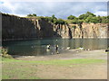
2
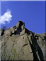
Nice sport climb
Cliff at the left side, of the flooded part of Prestonhill Quarry.
Image: © Thomas Stenhouse
Taken: 19 Apr 2008
0.11 miles
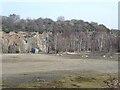
3
Preston Hill quarry
Disused quarry, with recent rock fall
Image: © Thomas Stenhouse
Taken: 20 Mar 2008
0.11 miles
4
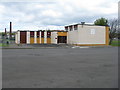
Ballast Bank sports pavilion, Inverkeithing
The home of Inverkeithing Hillfield Swifts F.C.
Image: © M J Richardson
Taken: 4 May 2012
0.14 miles
6
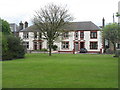
Houses, Preston Crescent
Facing the Ballast Bank sports ground.
Image: © M J Richardson
Taken: 4 May 2012
0.15 miles
7
Preston Hill Quarry - Inverkeithing
The old quarry workings lay close to the Fife Coastal Footpath.
Image: © Frank Smith
Taken: 14 Sep 2013
0.16 miles
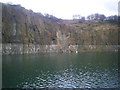
8
Prestonhill Quarry
The Prestonhill Quarry extracted dolerite over the period 1890 to 1980 (approximately) before being abandoned. The derelict site includes a large lake. There are proposals to redevelop the site with the construction of 180 houses, a cafe, a park and community facilities.
Image: © Oliver Dixon
Taken: 22 Mar 2022
0.17 miles
9
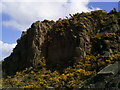
Prestonhill Quarry
Rock formations at Prestonhill Quarry.
Image: © Thomas Stenhouse
Taken: 19 Apr 2008
0.17 miles
10
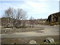
Prestonhill Quarry
The Prestonhill Quarry extracted dolerite over the period 1890 to 1980 (approximately) before being abandoned. The derelict site includes a large lake. There are proposals to redevelop the site with the construction of 180 houses, a cafe, a park and community facilities.
Image: © Oliver Dixon
Taken: 22 Mar 2022
0.18 miles