IMAGES TAKEN NEAR TO
Curlew Way, INVERKEITHING, KY11 1FG
Introduction
This page details the photographs taken nearby to Curlew Way, KY11 1FG by members of the Geograph project.
The Geograph project started in 2005 with the aim of publishing, organising and preserving representative images for every square kilometre of Great Britain, Ireland and the Isle of Man.

There are currently over 7.5m images from over14,400 individuals and you can help contribute to the project by visiting https://www.geograph.org.uk
Image Map
Images are licensed for reuse under creativecommons.org/licenses/by-sa/2.0
Notes
- Clicking on the map will re-center to the selected point.
- The higher the marker number, the further away the image location is from the centre of the postcode.
Image Listing (5 Images Found)
Images are licensed for reuse under creativecommons.org/licenses/by-sa/2.0
Image
Details
Distance
1
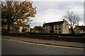
Houses, Concorde Way
The eastern edge of Inverkeithing. Looking north to Hillend Road along Agnes Paterson Wynd.
Image: © M J Richardson
Taken: 4 May 2012
0.07 miles
2
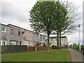
Concorde Way, Inverkeithing
With a path leading through to the edge of the estate and Agnes Paterson Wynd and farmland.
Image: © M J Richardson
Taken: 4 May 2012
0.09 miles
3
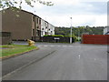
Concorde Way, Inverkeithing
Housing estate on the eastern outskirts of Inverkeithing.
Image: © M J Richardson
Taken: 4 May 2012
0.10 miles
4
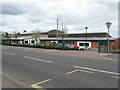
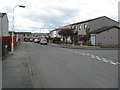
Inverkeithing Primary School
On Hillend Road, adjacent to the High School.
Image: © M J Richardson
Taken: 4 May 2012
0.20 miles