IMAGES TAKEN NEAR TO
Niven Road, INVERKEITHING, KY11 1EE
Introduction
This page details the photographs taken nearby to Niven Road, KY11 1EE by members of the Geograph project.
The Geograph project started in 2005 with the aim of publishing, organising and preserving representative images for every square kilometre of Great Britain, Ireland and the Isle of Man.

There are currently over 7.5m images from over14,400 individuals and you can help contribute to the project by visiting https://www.geograph.org.uk
Image Map
Images are licensed for reuse under creativecommons.org/licenses/by-sa/2.0
Notes
- Clicking on the map will re-center to the selected point.
- The higher the marker number, the further away the image location is from the centre of the postcode.
Image Listing (102 Images Found)
Images are licensed for reuse under creativecommons.org/licenses/by-sa/2.0
Image
Details
Distance
1
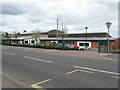
Inverkeithing Primary School
On Hillend Road, adjacent to the High School.
Image: © M J Richardson
Taken: 4 May 2012
0.12 miles
3
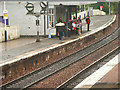
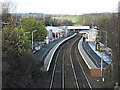
Inverkeithing Railway Station
Platform 1 to Edinburgh. In the olden days Inverkeithing was very important and was the hub of rail travel. Why ... even in Calcutta, Bombay, Singapore or Shanghai the guard or ticket clerk would remind you, "Don't forget to change at Inverkeithing!"
This part of the Scottish East Coast Mainline is no stranger to the occasional visitor from bygone eras of steam or old diesel.
A Gresley K4 2-6-0 steam engine No.61994 'The Great Marquess' http://youtube.com/watch?v=Mec3YXIRQvM passes through Inverkeithing heading North on its way to Dalgety Bay and again on the return leg via the West Fife Line from Cowdenbeath heading South: http://youtube.com/watch?v=0UD6J0ty2Sc.
A Class 55 Deltic No.55020 'Royal Scots Grey' pulls out of Inverkeithing station. http://youtube.com/watch?v=MBOCTAuGJbA
Image: © Simon Johnston
Taken: 18 Aug 2005
0.16 miles
4
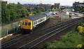
Railway junction at Inverkeithing
A peak-hour train for employees of Rosyth dockyard joins the ECML to the south of Inverkeithing station. The train continued to Kirkcaldy.
Image: © Albert Bridge
Taken: 19 Jun 1984
0.16 miles
5

Platform End at Inverkeithing, 1988
Looking south at the end of Inverkeithing Station, with Boreland Road bridge just visible
Image: © Rob Newman
Taken: 29 Jul 1988
0.17 miles
6
Inverkeithing railway station
Looking into the station from the Boreland Road bridge.
Image: © Thomas Nugent
Taken: 23 Dec 2015
0.17 miles
7
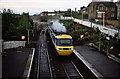
Accelerating Through Inverkeithing
The driver of an early morning northbound train opens the throttle in Inverkeithing station. In the far distance beyond the houses the top of the Forth Bridge is visible. The track diverging from the main line on the left is the Rosyth Dockyard branch. The bridge that the train has just passed under carries Boreland Road. The station was undergoing an upgrade to its lighting when this image was taken - one of the existing lights with the station name stands alongside one of the new lights and a stack of more new lights awaiting erection.
Image: © Martin Addison
Taken: Unknown
0.17 miles
9
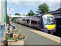
Inverkeithing railway station
Nearest the camera is Class 170 train number 170411 which is heading north.
Image: © Thomas Nugent
Taken: 7 Sep 2013
0.17 miles
10
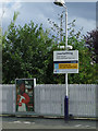
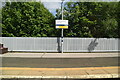
Inverkeithing railway station
Information signs about local paths which are served by the station.
Image: © Thomas Nugent
Taken: 7 Sep 2013
0.17 miles