IMAGES TAKEN NEAR TO
Deas Road, INVERKEITHING, KY11 1BH
Introduction
This page details the photographs taken nearby to Deas Road, KY11 1BH by members of the Geograph project.
The Geograph project started in 2005 with the aim of publishing, organising and preserving representative images for every square kilometre of Great Britain, Ireland and the Isle of Man.

There are currently over 7.5m images from over14,400 individuals and you can help contribute to the project by visiting https://www.geograph.org.uk
Image Map
Images are licensed for reuse under creativecommons.org/licenses/by-sa/2.0
Notes
- Clicking on the map will re-center to the selected point.
- The higher the marker number, the further away the image location is from the centre of the postcode.
Image Listing (202 Images Found)
Images are licensed for reuse under creativecommons.org/licenses/by-sa/2.0
Image
Details
Distance
1
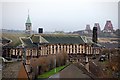
Disused school Inverkeithing
The former Inverkeithing primary school and in the distance the Forth Bridge Image
Image: © Paul Mc Ilroy
Taken: 20 Feb 2007
0.01 miles
2
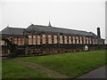
Former Inverkeithing Primary School
The former school was built in 1874 (juniors) and 1913 (seniors) and is situated on Roods Road.
Corporal Punishment ceased in Scottish state schools in 1986 but Fife Council have just allowed former Inverkeithing Primary School building to be flogged http://www.geograph.org.uk/discuss/index.php?action=vthread&topic=8732#1 at auction.
Image: © Simon Johnston
Taken: 7 Oct 2008
0.03 miles
3
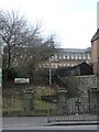
Inverkeithing Primary School (Closed)
The school is now closed, boarded up and trying to be redeveloped as an industrial/storage unit. Often a night time hang out for the local youths.
Image: © Steve Barnes
Taken: 19 Mar 2010
0.03 miles
4
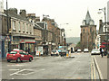
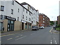
Inverkeithing
High Street. The town centre.
Image: © Simon Johnston
Taken: 18 Aug 2005
0.04 miles
5
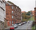
Hill Street Inverkeithing
Hill Street, as the name suggests, is on a steep hill, it connects Inverkeithing Square to Dunfermline Wynd. The large tenement building on the left is called Queen Mary Terrace.
Image: © Paul McIlroy
Taken: 18 Nov 2007
0.06 miles
7
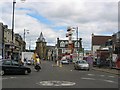
Inverkeithing
Town centre, the shows are in town, and a cycle tourist passes through. Inverkeithing is on several promoted cycle routes including the big one around the North Sea.
Image: © Richard Webb
Taken: 6 Aug 2005
0.08 miles
8
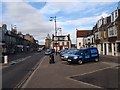
High Street, Inverkeithing
Quiet day in Inverkeithing
Image: © Graeme Smith
Taken: 20 Sep 2009
0.09 miles
9
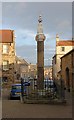
Inverkeithing Mercat Cross
Situated at the north end of Inverkeithing Square and the beginning of Bank Street,the pillar section of this monument dates back to about 1400 while the Unicorn on the top was carved in 1688.
Image: © Paul McIlroy
Taken: 15 Jan 2007
0.09 miles
10
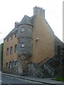
Fordell's Lodging, Church Street
An L-plan tower house built by Sir John Henderson of Fordell in 1671. The Hendersons were hereditary provosts of the burgh.
Image: © kim traynor
Taken: 20 Apr 2011
0.09 miles