IMAGES TAKEN NEAR TO
Hill Street, INVERKEITHING, KY11 1AB
Introduction
This page details the photographs taken nearby to Hill Street, KY11 1AB by members of the Geograph project.
The Geograph project started in 2005 with the aim of publishing, organising and preserving representative images for every square kilometre of Great Britain, Ireland and the Isle of Man.

There are currently over 7.5m images from over14,400 individuals and you can help contribute to the project by visiting https://www.geograph.org.uk
Image Map
Images are licensed for reuse under creativecommons.org/licenses/by-sa/2.0
Notes
- Clicking on the map will re-center to the selected point.
- The higher the marker number, the further away the image location is from the centre of the postcode.
Image Listing (80 Images Found)
Images are licensed for reuse under creativecommons.org/licenses/by-sa/2.0
Image
Details
Distance
1
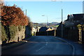
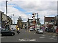
Inverkeithing
Dunfermline Wynd leads westwards from Inverkeithing Square across The A90 to Castlandhill Road. This view is NE towards The Cullaloe Hills.
Image: © Paul McIlroy
Taken: 10 Jan 2007
0.09 miles
2
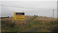
Hilltop des res to come
In the land bank. A hill top site above the A90 on the edge of Inverkeithing.
Image: © Richard Webb
Taken: 15 Oct 2009
0.09 miles
3
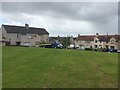
Hillfield Crescent, Inverkeithing
A hilltop open space surrounded by houses. The flatbed had been parked for sometime and was surrounded by long grass.
Image: © Richard Webb
Taken: 5 Jul 2020
0.14 miles
4
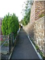
Line of the old town wall, Inverkeithing
This path runs in a straight line between a Victorian tenement block off to the right and more modern housing off to the left. Since it lines up exactly with a surviving section of town wall across the gap created by the roadway where the West Port once stood, I deduce that it follows the line of the old town wall.
Image: © kim traynor
Taken: 16 Oct 2011
0.14 miles
5
Inverkeithing
Town centre, the shows are in town, and a cycle tourist passes through. Inverkeithing is on several promoted cycle routes including the big one around the North Sea.
Image: © Richard Webb
Taken: 6 Aug 2005
0.14 miles
6
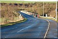
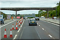
Dunfermline Wynd
Where it crosses The A90 to join Castlandhill Road.Image
Image: © Paul McIlroy
Taken: 10 Jan 2007
0.14 miles
7
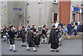
Pipe band, Inverkeithing
At the end of the Inverkeithing Highland Games pipe bands march into the town. Taken in the centre of town, by the Kirk.
Image: © Richard Webb
Taken: 6 Aug 2005
0.14 miles
8
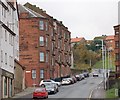
Hill Street Inverkeithing
Hill Street, as the name suggests, is on a steep hill, it connects Inverkeithing Square to Dunfermline Wynd. The large tenement building on the left is called Queen Mary Terrace.
Image: © Paul McIlroy
Taken: 18 Nov 2007
0.14 miles
10
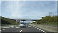
Bridge over the A90 near Dunfermline
Dunfermline Wynd crossing the A90.
Image: © David Dixon
Taken: 23 May 2017
0.15 miles