IMAGES TAKEN NEAR TO
Castle Walk, ANSTRUTHER, KY10 3SP
Introduction
This page details the photographs taken nearby to Castle Walk, KY10 3SP by members of the Geograph project.
The Geograph project started in 2005 with the aim of publishing, organising and preserving representative images for every square kilometre of Great Britain, Ireland and the Isle of Man.

There are currently over 7.5m images from over14,400 individuals and you can help contribute to the project by visiting https://www.geograph.org.uk
Image Map
Images are licensed for reuse under creativecommons.org/licenses/by-sa/2.0
Notes
- Clicking on the map will re-center to the selected point.
- The higher the marker number, the further away the image location is from the centre of the postcode.
Image Listing (541 Images Found)
Images are licensed for reuse under creativecommons.org/licenses/by-sa/2.0
Image
Details
Distance
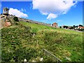
1
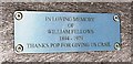
Memorial plaque on seat, Crail
In the grassy area below Castle Walk, Crail are several bench seats for the use of visitors. All of them have an inscription or dedication plaque on them. This one is close to The Watch House Image
Image: © Bill Kasman
Taken: 5 Aug 2017
0.00 miles
2
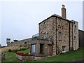
The Watch House
The Category C listed https://portal.historicenvironment.scot/designation/LB23471 building is dated 1782 and includes re-used 17th century elements within the fabric. The wooden-clad extension with seating area above has recently been constructed to replace an older brick extension with pan-tiled roof. The stonework has been repointed with lime mortar.
Image: © Richard Sutcliffe
Taken: 23 Sep 2024
0.00 miles
3
The Watch House
Seen from Castle Walk. Compare with a similar view from 2023 Image
The Category C listed https://portal.historicenvironment.scot/designation/LB23471 building is dated 1782 and includes re-used 17th century elements within the fabric. The wooden-clad extensions have recently been constructed and the stonework has been repointed with lime mortar.
Image: © Richard Sutcliffe
Taken: 23 Sep 2024
0.00 miles
4
The Watch House, Crail
From the same position as this image Image these steps lead up into the heart of Crail. The house at the top of the steps is called The Watch House. Castle Walk Image runs to the left from there.
Image: © Bill Kasman
Taken: 5 Aug 2017
0.01 miles
5
A Crail view
The Watch House at the left dates from the late 18th century and is Categeory C listed https://portal.historicenvironment.scot/designation/LB23471.
Image: © Richard Sutcliffe
Taken: 13 Jun 2023
0.01 miles
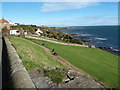
7
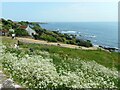
A patch of cow parsley
On the coast at Crail.
Image: © Richard Sutcliffe
Taken: 13 Jun 2023
0.02 miles
8
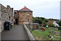
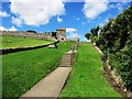
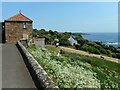
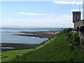
Castle Walk, Crail
The footpath of Castle Walk runs below the wall. The sundial in this image Image is immediately below the tower on the left.
Image: © Bill Kasman
Taken: 5 Aug 2017
0.03 miles
10
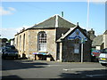
Crail Royal British Legion
Located in the town square. There was a book sale on in the Legion building this particular day, but it wasn't all that busy.
Image: © Richard Law
Taken: 29 Aug 2008
0.03 miles