IMAGES TAKEN NEAR TO
Anstruther Road, ANSTRUTHER, KY10 3RJ
Introduction
This page details the photographs taken nearby to Anstruther Road, KY10 3RJ by members of the Geograph project.
The Geograph project started in 2005 with the aim of publishing, organising and preserving representative images for every square kilometre of Great Britain, Ireland and the Isle of Man.

There are currently over 7.5m images from over14,400 individuals and you can help contribute to the project by visiting https://www.geograph.org.uk
Image Map
Images are licensed for reuse under creativecommons.org/licenses/by-sa/2.0
Notes
- Clicking on the map will re-center to the selected point.
- The higher the marker number, the further away the image location is from the centre of the postcode.
Image Listing (324 Images Found)
Images are licensed for reuse under creativecommons.org/licenses/by-sa/2.0
Image
Details
Distance
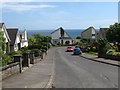
2
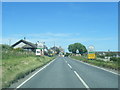
A917 - Leaving Crail (for the other East Neuk Villages)
The Fife Coastal Path turns to the left at this point.
Image: © Sandy Gemmill
Taken: 19 Oct 2007
0.03 miles
3
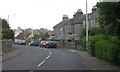
A917 entering Crail
Entering from the west, that is. The junction on the right is with West Braes.
Image: © Derek Harper
Taken: 17 Aug 2008
0.03 miles
5
Detached villas in Crail
Crail is the last fishing village at the east end of the East Neuk of Fife.
Image: © James Denham
Taken: 2 Jun 2010
0.05 miles
6
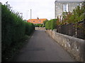
Fife Coastal Path approaching the main road into Crail
The Fife Coastal Path leaves the coast line and goes through the village of Crail
Image: © Sandy Gemmill
Taken: 19 Oct 2007
0.06 miles
7
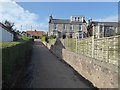
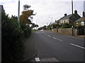
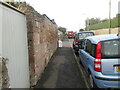
Top end of West Braes
The red-roofed bungalow is on the far side of the main Anstruther road.
Image: © Oliver Dixon
Taken: 17 Oct 2019
0.07 miles
8
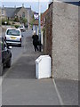
Milestone, Anstruther Road
The milestone stands beside the A917, Anstruther Road on the outskirts of Crail.
Milestones are the original roadside heritage features with many dating back hundreds of years and these historic items are under threat from highway developments.
Image: © Maigheach-gheal
Taken: 14 Apr 2011
0.07 miles
9
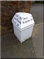
Milestone, Anstruther Road
The milestone stands beside the A917, Anstruther Road.
Milestones did not come into general use until the Turnpike Act of 1766 made them compulsory on turnpike roads, these roads were built by private enterprise under licence from the Government and maintained by tolls on those who used them. Before this Act milestones were put up occasionally, often as charitable acts and commemorations. Many Turnpike Act stones still exist. They are usually 2-3 ft high, with the initial letter or abbreviation of the nearest market town shown on two faces, and the distance from it.
For a wider view Image
Image: © Maigheach-gheal
Taken: 14 Apr 2011
0.07 miles
10
A917 Milestone in Crail
Milestone with cast-iron cap on Anstruther Road in Crail.
Image: © Scott Cormie
Taken: 6 Oct 2020
0.08 miles