IMAGES TAKEN NEAR TO
High Street South, ANSTRUTHER, KY10 3RB
Introduction
This page details the photographs taken nearby to High Street South, KY10 3RB by members of the Geograph project.
The Geograph project started in 2005 with the aim of publishing, organising and preserving representative images for every square kilometre of Great Britain, Ireland and the Isle of Man.

There are currently over 7.5m images from over14,400 individuals and you can help contribute to the project by visiting https://www.geograph.org.uk
Image Map
Images are licensed for reuse under creativecommons.org/licenses/by-sa/2.0
Notes
- Clicking on the map will re-center to the selected point.
- The higher the marker number, the further away the image location is from the centre of the postcode.
Image Listing (562 Images Found)
Images are licensed for reuse under creativecommons.org/licenses/by-sa/2.0
Image
Details
Distance
1
46 High Street, Crail
Dates from the 17th century, but with 18th century alterations, and Category B listed https://britishlistedbuildings.co.uk/200359034-46-high-street-east-neuk-and-landward-ward#.XABXXdSLTGg in 1972.
Image: © Richard Law
Taken: 5 Oct 2018
0.00 miles
2
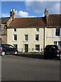
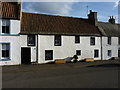
52 High Street, Crail
Nos 48 & 52 are jointly Category B listed https://britishlistedbuildings.co.uk/200359036-48-and-52-high-street-east-neuk-and-landward-ward#.XABX9tSLTGg, but 48 to the left here was rather obscured by parked cars on this occasion. They are both 17th century in origin, albeit with alterations in the 19th, and quite recent restoration in the 20th.
Image: © Richard Law
Taken: 5 Oct 2018
0.01 miles
3
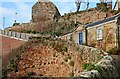
Hen's Ladder, Crail
Hen's Ladder runs between the harbour and the Westgate/High Street above. The Ladder was rebuilt five years ago in 2001 after major building work to its cliff side supporting structure on the left of shot. The Hen's Ladder provides some of the best views of the harbour area as well as being an important quick link for local pedestrians.
Image: © Jim Bain
Taken: 30 Dec 2006
0.01 miles
4
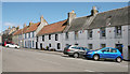
High Street, Crail
There is a steep camber on the road at this point.
Image: © Richard Sutcliffe
Taken: 24 May 2019
0.01 miles
5
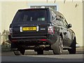
1 GEO
I couldn't resist photographing this Range Rover in Crail with the number plate 1 GEO. It could be Geograph's personalised number plate!
Image: © Philip Halling
Taken: 28 Jun 2019
0.01 miles
6
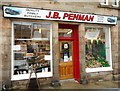
Butchers' shop
J.B. Penman, quality family butchers, on High Street, Crail.
Image: © Richard Sutcliffe
Taken: 25 Sep 2019
0.01 miles
7
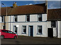
54 High Street, Crail
A 17th century cottage which attracted a Category B listing https://britishlistedbuildings.co.uk/200359037-54-high-street-east-neuk-and-landward-ward#.XABY69SLTGg in 1972. The small blue plaque just to the right of the doorway is the logo of Historic Scotland, and effectively acknowledges the listing.
Image: © Richard Law
Taken: 5 Oct 2018
0.01 miles
8
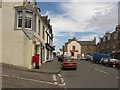
Crail Post Office
The post office on Crail High Street.
Image: © Richard Webb
Taken: 3 Jul 2010
0.01 miles
9
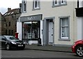
Shell's, High Street, Crail
Shop selling cards and gifts.
Image: © Richard Sutcliffe
Taken: 18 Mar 2019
0.01 miles
10
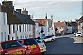
High Street, Crail
The A917 to Anstruther and Upper Largo.
Image: © Jim Barton
Taken: 18 Sep 2013
0.02 miles