IMAGES TAKEN NEAR TO
Smithy Brae, ANSTRUTHER, KY10 3JN
Introduction
This page details the photographs taken nearby to Smithy Brae, KY10 3JN by members of the Geograph project.
The Geograph project started in 2005 with the aim of publishing, organising and preserving representative images for every square kilometre of Great Britain, Ireland and the Isle of Man.

There are currently over 7.5m images from over14,400 individuals and you can help contribute to the project by visiting https://www.geograph.org.uk
Image Map
Images are licensed for reuse under creativecommons.org/licenses/by-sa/2.0
Notes
- Clicking on the map will re-center to the selected point.
- The higher the marker number, the further away the image location is from the centre of the postcode.
Image Listing (160 Images Found)
Images are licensed for reuse under creativecommons.org/licenses/by-sa/2.0
Image
Details
Distance
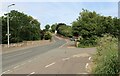
1
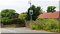
Speed warning sign on A917
As it enters the village of Kilrenny. These signs give a visual reminder of a vehicles' speed. The vehicle which triggered this sign is well within the speed limit as can be seen from the posted speed limit sign on the lamp post to the left of the image.
See main article https://www.geograph.org.uk/article/Kilrenny
Image: © Bill Kasman
Taken: 30 Jun 2021
0.01 miles
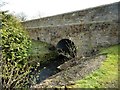
2
Kilrenny Bridge
Unable to meet the new EU weight limits for this old timer's more modern equivalents, the road authorities have got around the problem by fitting traffic lights to the bridge.
Image: © Jim Bain
Taken: 20 May 2007
0.03 miles
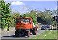
3
The A917 at Kilrenny
The road approaches the village from the direction of Crail.
See main article https://www.geograph.org.uk/article/Kilrenny
Image: © Bill Kasman
Taken: 30 Jun 2021
0.04 miles
4
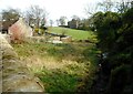
Smiddy Cottage and Kilrenny Burn
In the distance is the Category B listed, early 19th century Kilrenny House.
Image: © Richard Sutcliffe
Taken: 20 Mar 2019
0.04 miles
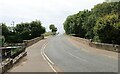
5
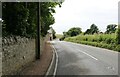
The A917 at Kilrenny
The road crosses the recently renovated bridge. The turn to the right leads to Kilrenny House, Kilrenny Mill Caravan Park and the village of Cellardyke. It is unsurfaced for most of its length.
See main article https://www.geograph.org.uk/article/Kilrenny
Image: © Bill Kasman
Taken: 30 Jun 2021
0.05 miles
6
Bridge over the Kilrenny Burn
A substantial bridge carries the A917 over the burn. Seen from the corner of the churchyard.
Image: © Richard Sutcliffe
Taken: 20 Mar 2019
0.05 miles
7
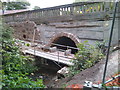
Bridge repairs
This bridge carrying the A917 road between Anstruther and Crail has for several years been restricted by traffic lights to a one-way system. Now at last, having meantime cost road users a small fortune in fuel, brake-linings and time, Fife Council roads department appears to be reopening it to two-way traffic.
Image: © James Allan
Taken: 20 Jul 2017
0.06 miles
8
The A917 at Kilrenny
The bridge over the Kilrenny Burn was repaired and renovated in 2017 https://www.geograph.org.uk/photo/5496702 Prior to that the road here was quite narrow and the bridge was in poor condition. Traffic lights were in place to control traffic.
See main article https://www.geograph.org.uk/article/Kilrenny
Image: © Bill Kasman
Taken: 30 Jun 2021
0.06 miles
9
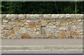
The A917 at Kilrenny
The road bridge on the A917 at Kilrenny was repaired and strengthened in 2017. This dated stone marks the year the bridge was originally constructed.
See main article https://www.geograph.org.uk/article/Kilrenny
Image: © Bill Kasman
Taken: 30 Jun 2021
0.06 miles
10
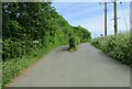
Unmetalled roads near Kilrenny
These two roads leave the A917 at Kilrenny. The one on the left leads to Kilrenny House and the one on the right leads to Kilrenny Mill Caravan Park and Cellardyke.
See main article https://www.geograph.org.uk/article/Kilrenny
Image: © Bill Kasman
Taken: 30 Jun 2021
0.06 miles