IMAGES TAKEN NEAR TO
Kilrenny, ANSTRUTHER, KY10 3JF
Introduction
This page details the photographs taken nearby to KY10 3JF by members of the Geograph project.
The Geograph project started in 2005 with the aim of publishing, organising and preserving representative images for every square kilometre of Great Britain, Ireland and the Isle of Man.

There are currently over 7.5m images from over14,400 individuals and you can help contribute to the project by visiting https://www.geograph.org.uk
Image Map
Images are licensed for reuse under creativecommons.org/licenses/by-sa/2.0
Notes
- Clicking on the map will re-center to the selected point.
- The higher the marker number, the further away the image location is from the centre of the postcode.
Image Listing (184 Images Found)
Images are licensed for reuse under creativecommons.org/licenses/by-sa/2.0
Image
Details
Distance
1
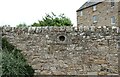
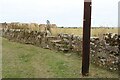
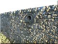
What is this?
This recess in the wall is a bit of a mystery. There was no indication as to its purpose. The building is Rennyhill Farm Lodge.
See main article https://www.geograph.org.uk/article/Kilrenny
Image: © Bill Kasman
Taken: 24 Jul 2021
0.01 miles
2
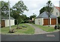
Rennyhill Gardens
See main article https://www.geograph.org.uk/article/Kilrenny
Image: © Bill Kasman
Taken: 24 Jul 2021
0.02 miles
3
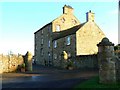
Kilrenny House
Other than the church tower, the tallest building in Kilrenny village.
Image: © James Allan
Taken: 2 Jun 2014
0.02 miles
4
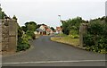
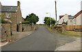
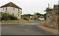
Kilrenny (road)
The turning to the right is Main Street.
See main article https://www.geograph.org.uk/article/Kilrenny
Image: © Bill Kasman
Taken: 24 Jul 2021
0.03 miles
5
Steps into field
This set of well-worn steps don't actually lead anywhere. Presumably there was once a path on the other side of the wall but I could find no trace of it.
See main article https://www.geograph.org.uk/article/Kilrenny
Image: © Bill Kasman
Taken: 24 Jul 2021
0.03 miles
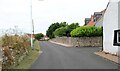
6
Kilrenny (road)
The turning to the left between the stone pillars is the driveway of Rennyhill Farm Lodge. That to the right leads into Rennyhill farmyard.
See main article https://www.geograph.org.uk/article/Kilrenny
Image: © Bill Kasman
Taken: 24 Jul 2021
0.03 miles
7
Path in Kilrenny
This path from Rennyhill Gardens leads to a grassy area within which is an old dovecot which once served Kilrenny House. It is one of two dovecots in the village.
See main article https://www.geograph.org.uk/article/Kilrenny
Image: © Bill Kasman
Taken: 2 Aug 2021
0.03 miles
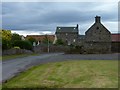
8
Rennyhill House
An impressive dwelling near the centre of Kilrenny village. Note the unusual decorative 'port-hole' windows high on the gable end.
Image: © James Allan
Taken: 8 Jan 2009
0.04 miles
9
Blacklaws Crescent
Immediately to the right of the two cars a footpath leads to the picnic area and children's play area.
See main article https://www.geograph.org.uk/article/Kilrenny
Image: © Bill Kasman
Taken: 24 Jul 2021
0.04 miles
10
Hemispherical hollow
Unusual feature incorporated into the stone garden wall of Rennyhill House.
Image: © James Allan
Taken: 8 Jan 2009
0.05 miles