IMAGES TAKEN NEAR TO
St. Andrews Road, ANSTRUTHER, KY10 3GY
Introduction
This page details the photographs taken nearby to St. Andrews Road, KY10 3GY by members of the Geograph project.
The Geograph project started in 2005 with the aim of publishing, organising and preserving representative images for every square kilometre of Great Britain, Ireland and the Isle of Man.

There are currently over 7.5m images from over14,400 individuals and you can help contribute to the project by visiting https://www.geograph.org.uk
Image Map
Images are licensed for reuse under creativecommons.org/licenses/by-sa/2.0
Notes
- Clicking on the map will re-center to the selected point.
- The higher the marker number, the further away the image location is from the centre of the postcode.
Image Listing (58 Images Found)
Images are licensed for reuse under creativecommons.org/licenses/by-sa/2.0
Image
Details
Distance
1
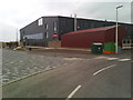
Waid Academy
Recently constructed new school and community facilities building.
Image: © James Allan
Taken: 1 May 2017
0.01 miles
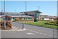
2

New Waid Academy, Anstruther
This newly-built school is a replacement for the old Waid Academy https://www.thecourier.co.uk/news/local/fife/240053/backing-for-new-24-million-waid-academy/
Image: © Bill Kasman
Taken: 5 Aug 2017
0.06 miles
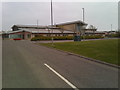
3
Anstruther Primary
The all new Anstruther Primary school built to replace the two original primaries on a new site close to the Waid Academy. It straddle two grids but the majority is in this grid.
Image: © Jim Bain
Taken: 6 May 2007
0.08 miles
4
Anstruther Primary School
Taken from close to the new Waid Academy building.
Image: © James Allan
Taken: 1 May 2017
0.10 miles
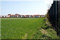
5
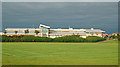
Anstruther Primary School
From the west looking across the rugby fields with a rain laden front coming in from the east.
Image: © Jim Bain
Taken: 12 Sep 2008
0.10 miles
6
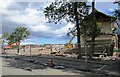
Demolition site, Anstruther
Part of the old Waid Academy is being demolished https://www.thecourier.co.uk/news/local/fife/240053/backing-for-new-24-million-waid-academy/
Image: © Bill Kasman
Taken: 5 Aug 2017
0.14 miles
7
North Anstruther
Edge of new developments on the northern edge of Anstruther/Cellardyke. The big black security fence belongs to the new primary school.
Image: © Jim Bain
Taken: 6 May 2007
0.15 miles
8
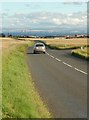
B9131
Heading south towards Anstruther by the Caulcots junction.
Image: © Jim Bain
Taken: 6 Aug 2007
0.15 miles
9
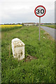
Milestone just outside Anstruther
The distances on the milestone to Anstruther, Kilrenny and Pittenweem (and those to St Andrews, Leuchars and Newport on the other side) are all a mile out. They read:
ANS,R. 1 ½
KILR,Y. 2 3/8
PITT,M. 2 5/8
These distances are the same as those on the next milestone to the north at Pitkeirie https://www.geograph.org.uk/photo/2807000. See https://canmore.org.uk/site/305867/anstruther.
Image: © Richard Sutcliffe
Taken: 19 May 2019
0.15 miles
10
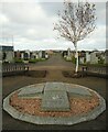
War memorial, New Cemetery, Anstruther
Privet hedges, which used to surround the memorial (behind the seats) have recently been removed.
Image: © Richard Sutcliffe
Taken: 28 Oct 2020
0.15 miles