IMAGES TAKEN NEAR TO
Blyth Court, ANSTRUTHER, KY10 3EG
Introduction
This page details the photographs taken nearby to Blyth Court, KY10 3EG by members of the Geograph project.
The Geograph project started in 2005 with the aim of publishing, organising and preserving representative images for every square kilometre of Great Britain, Ireland and the Isle of Man.

There are currently over 7.5m images from over14,400 individuals and you can help contribute to the project by visiting https://www.geograph.org.uk
Image Map
Images are licensed for reuse under creativecommons.org/licenses/by-sa/2.0
Notes
- Clicking on the map will re-center to the selected point.
- The higher the marker number, the further away the image location is from the centre of the postcode.
Image Listing (133 Images Found)
Images are licensed for reuse under creativecommons.org/licenses/by-sa/2.0
Image
Details
Distance
1
March Place, Cellardyke
Junction of March Place and Toll Road
Image: © Jim Bain
Taken: 27 Apr 2006
0.04 miles
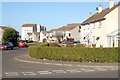
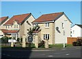
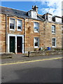
2
Blyth Court, Anstruther
Modern housing on the northern edge of town
Image: © Jim Bain
Taken: 28 Sep 2008
0.07 miles
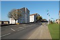
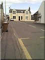
4
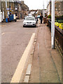
Bus stop in Fowler Street
Looking west, towards Anstruther.
Image: © James Allan
Taken: 15 Apr 2015
0.08 miles
5
Guardroom, RAF Anstruther
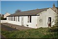
The guardroom to the former domestic site of RAF Anstruther. Behind me were the barrack blocks for the RAF station which went on to see service as Anstruther's holiday village and have now been pulled down and a modern development is now taking place. The buildings to the right of the old guardroom on Toll Road were married quarters for other ranks.
RAF Anstruther was part of the Chain Home system (CH). Chain Home was the world's first RADAR system to see active service. CH was developed in the pre war years by a team led by Watson Watt who to my mind was a bit of an unsung hero of the time. It was primitive, but when your back's against the wall you go with what you have got. In 1939 Britain did and CH worked.
RAF Anstruther's operational site and its masts were, to the best of my ability, thought to have been in the area of NO5608. This area went on to become the site of the cold war "secret bunker". Totally open to corrections please email me via the site. Thanks to James Allan and Dennis Anderson for further information about the station.
Image: © Jim Bain
Taken: 27 Apr 2006
0.09 miles
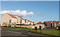
6
The Marches, Cellardyke
A new housing development at Cellardyke. The 1969 version of the old 1" map makes no mention of this place name, using only "Anstruther Easter".
Image: © Mary and Angus Hogg
Taken: 15 Sep 2012
0.09 miles
7
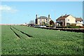
Crail Road, Anstruther
One of the three main roads into town. A new housing development is taking shape to the right of shot hence all the flags.
Image: © Jim Bain
Taken: 27 Apr 2006
0.10 miles
8
Cellardyke
Cellardyke by the police station from the Pitkierie path.
Image: © Jim Bain
Taken: 6 May 2007
0.12 miles
9
16 Rodger Street, Cellardyke
All the houses in Rodger Street are Category B listed https://britishlistedbuildings.co.uk/200397554-cellardyke-rodger-street-nos-10-14-38-even-nos-including-boundary-walls-and-ancillary-buildings-east-neuk-and-landward-ward#.W_gBgdSLTGg, this one being just one example of the 13 on the east side of the road. The street was built in the late 1870s/early 1880s as paired tenements for fishermen of the town; the houses had net-drying space in front of each, and storage sheds included at the rear along with attics for repair. It is named in honour of Alexander Rodger, a merchant sea captain and owner of tea clipper vessels in the middle of the 19th century, who made significant improvements to Cellardyke harbour in the 1860s.
Image: © Richard Law
Taken: 4 Oct 2018
0.12 miles
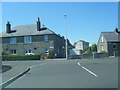
10
House in Toll Road
Seen from Fowler Place
Image: © James Allan
Taken: 15 Apr 2015
0.13 miles