1
53 High Street, Anstruther Easter
The doorway in the rubblestone gable end is 13 Tolbooth Wynd, whilst the main ashlar frontage of the house is 53 High Street. It dates from 1818, and was Category C listed http://portal.historicenvironment.scot/designation/LB36090 in 1972
Image: © Richard Law
Taken: 5 May 2021
0.00 miles
2
8 - 13 Tolbooth Wynd, Anstruther Easter
The narrow alleyway of Tolbooth Wynd, leading off northwards from Shore Street up to High Street East. All the houses in view on the right here date from the late 17th or early 18th century, and were Category B listed https://britishlistedbuildings.co.uk/200380800-8-10-tolbooth-wynd-anstruther-easter-kilrenny#.YR6VFo5KjIU in 1972.
Image: © Richard Law
Taken: 5 May 2021
0.01 miles
3
55 High Street, Anstruther Easter
No 55 dates from the early 19th century, and was Category C listed https://britishlistedbuildings.co.uk/200380802-club-55-high-street-east-anstruther-easter-kilrenny#.YR6a4Y5KjIU in 1972. The plaque on the front wall by the doorway describes it as the base of the Waid Academy Former Pupils' Rugby Club.
Image: © Richard Law
Taken: 5 May 2021
0.01 miles
4
High Street, Anstruther Easter
Image: © Richard Sutcliffe
Taken: 22 Mar 2019
0.01 miles
5
Pets Pantry, High Street, Anstruther Easter
Pet shop. The sign on the wall advertises:
Small Pets and Fish
Poultry and equine section
Bulk foods and bedding for all animals
Food, treats and accessories for dogs, cats and small pets
Image: © Richard Sutcliffe
Taken: 22 Mar 2019
0.01 miles
6
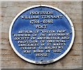
Blue plaque commemorating Professor William Tennant
On the wall of Pets Pantry, 56 High Street, Anstruther Easter [https://www.geograph.org.uk/photo/6118704]. The plaque reads:
PROFESSOR
WILLIAM TENNANT
1784-1848
POET
AUTHOR OF "ANSTER FAIR"
FOUNDER OF THE MUSOMANIK
SOCIETY OF ANSTRUTHER AND
PROFESSOR OF ORIENTAL
LANGUAGES IN ST. MARY'S
COLLEGE ST. ANDREWS
WAS BORN IN THIS
HOUSE
Image: © Richard Sutcliffe
Taken: 22 Mar 2019
0.01 miles
7
Former Masonic Lodge, High Street, Anstruther Easter
The building, which is on the corner of High Street and Cunzie Street has been vacant and boarded up since at least 2007. It is on the Buildings at Risk Register [https://www.buildingsatrisk.org.uk/details/907296].
Image: © Richard Sutcliffe
Taken: 22 Mar 2019
0.01 miles
8
Doorway, former Masonic Lodge, High Street, Anstruther Easter
The doorway has a distinctive stepped Tudor hood mould. The building has been vacant and boarded up since at least 2007. It is on the Buildings at Risk Register [https://www.buildingsatrisk.org.uk/details/907296].
Image: © Richard Sutcliffe
Taken: 22 Mar 2019
0.01 miles
9
57-61 High Street East, Anstruther Easter
The address of this building also includes 11 Cunzie Street, which forms the leftmost part of it as seen here. The part that faces us is 57-61 High Street East, and dates from the late 19th century. It has previously been used as a Masonic Lodge or Temple, and was Category C listed https://britishlistedbuildings.co.uk/200380804-masonic-lodge-57-61-high-street-east-anstruther-easter-kilrenny#.YpOvv6jMLIU in 1972. Sadly, a certain amount of dereliction has set in in recent years.
Image: © Richard Law
Taken: 6 May 2022
0.01 miles
10
East High Street, Anstruther
The far eastern end of the High Street from by Rodger Street and Pringles
Image: © Jim Bain
Taken: 21 Sep 2008
0.02 miles


