IMAGES TAKEN NEAR TO
Rodger Street, ANSTRUTHER, KY10 3DU
Introduction
This page details the photographs taken nearby to Rodger Street, KY10 3DU by members of the Geograph project.
The Geograph project started in 2005 with the aim of publishing, organising and preserving representative images for every square kilometre of Great Britain, Ireland and the Isle of Man.

There are currently over 7.5m images from over14,400 individuals and you can help contribute to the project by visiting https://www.geograph.org.uk
Image Map
Images are licensed for reuse under creativecommons.org/licenses/by-sa/2.0
Notes
- Clicking on the map will re-center to the selected point.
- The higher the marker number, the further away the image location is from the centre of the postcode.
Image Listing (642 Images Found)
Images are licensed for reuse under creativecommons.org/licenses/by-sa/2.0
Image
Details
Distance
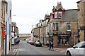
2
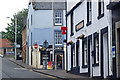
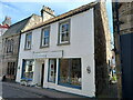
17 - 19 Rodger Street, Anstruther Easter
The two premises behind the car (the Optometrists and the orange shop frontage) occupy numbers 17, 18 & 19 Rodger Street, which date from the very early 20th century around 1903. They were collectively Category C listed https://britishlistedbuildings.co.uk/200380834-17-19-rodger-street-anstruther-easter-kilrenny#.YoVkeqjMLIU in 1972.
Image: © Richard Law
Taken: 6 May 2022
0.00 miles
3
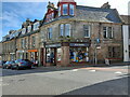
15 - 17 Rodger Street, Anstruther Easter
The main part of the building on the corner here is no 15 Rodger Street, but nos 16 & 17 share the same footprint by the look of the maps. The shop itself retains its original frontage, and the whole ensemble, including the upper storeys, was Category C listed https://britishlistedbuildings.co.uk/200380833-15-17-rodger-street-anstruther-easter-kilrenny#.YoVmUKjMLIU in 1972.
Image: © Richard Law
Taken: 6 May 2022
0.01 miles
4
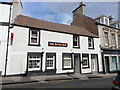
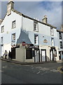
The Royal Bar at 20-22 Rodger Street, Anstruther Easter
Originally a separate building, but now effectively part of the adjoining Image on their left. 20-22 Rodger Street date from the late 18th century, and were Category C listed https://britishlistedbuildings.co.uk/200380843-20-22-rodger-street-anstruther-easter-kilrenny#.YoPfq-jMLIV in 1972.
Image: © Richard Law
Taken: 6 May 2022
0.01 miles
5
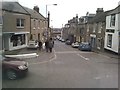
Rodger Street, Anstruther, Fife
View looking north up Rodger Street, Anstruther, in the East Neuk of Fife, Scotland.
Image: © Jerzy Morkis
Taken: 27 Jun 2020
0.01 miles
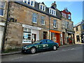
6
Rodger Street, Anstruther Easter
Looking towards the harbour.
Image: © Richard Sutcliffe
Taken: 17 Mar 2019
0.01 miles
7
Roger Street, Anstruther
Looking towards the harbour.
Image: © James Allan
Taken: 8 Apr 2016
0.01 miles
8
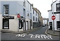
No Entry
Looking along High Street East in Anstruther. It is a one-way street. Munchies is a restaurant on the corner of High Street East and Rodger Street.
Image: © Richard Sutcliffe
Taken: 17 Mar 2019
0.01 miles
9
35 High Street East, Anstruther Easter
Originally built in the early 19th century as two shops (presumably with accommodation above them) this property at 35 High Street was Category C listed https://britishlistedbuildings.co.uk/200380795-35-high-street-east-anstruther-easter-kilrenny#.YogKvKjMLIU in 1972.
Image: © Richard Law
Taken: 6 May 2022
0.01 miles
10
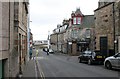
12 & 14 Rodger Street, Anstruther Easter
Also incorporating nos 38 & 40 High Street East, this extensive building dates from around the 18th century (although it includes a stone dated 1621, which was presumably removed from somewhere else) and was Category B listed https://britishlistedbuildings.co.uk/200380841-12-and-14-rodger-street-and-40-high-street-anstruther-easter-east-neuk-and-landward-ward#.W_m3HdSLTGg in 1972.
Image: © Richard Law
Taken: 4 Oct 2018
0.01 miles