1
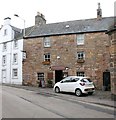
Dreel Tavern
Category B listed https://portal.historicenvironment.scot/designation/LB36217 former coaching inn, dating from the 17th and 18th centuries.
Image: © Richard Sutcliffe
Taken: 16 Jun 2023
0.00 miles
2
18 High Street, Anstruther Wester
Squeezed in between a terrace of slightly older cottages
Image and the
Image lies this late 18th century town house, which was Category B listed https://britishlistedbuildings.co.uk/200380948-18-high-street-anstruther-wester-east-neuk-and-landward-ward#.W4913OhKhPY in 1972.
Image: © Richard Law
Taken: 18 May 2018
0.00 miles
3
Dreel Tavern
Category B listed inn on High Street West, Anstruther Wester [http://portal.historicenvironment.scot/designation/LB36217]. The building dates from the 17th and 18th centuries.
Image: © Richard Sutcliffe
Taken: 17 Mar 2019
0.01 miles
4
Dreel Tavern
Category B listed inn on High Street, Anstruther Wester [http://portal.historicenvironment.scot/designation/LB36217]. The building dates from the 17th and 18th centuries.
Image: © Richard Sutcliffe
Taken: 17 Mar 2019
0.01 miles
5
High Street, Anstruther Wester
Image: © Richard Sutcliffe
Taken: 17 Mar 2019
0.01 miles
6
Dreel Tavern
Category B listed https://portal.historicenvironment.scot/designation/LB36217 former coaching inn, dating from the 17th and 18th centuries.
Image: © Richard Sutcliffe
Taken: 16 Jun 2023
0.01 miles
7
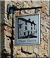
Sign for the Dreel Tavern
Public house on High Street West
Image
Image: © Richard Sutcliffe
Taken: 16 Jun 2023
0.01 miles
8
Dreel Tavern
This old public house sits on the side of the A917.
The blue sign on the wall says "James V 1513 - 1542 travelled incognito through Fife as 'The Guid Man o'Ballengiech'. Coming to the Dreel Burn, and fearful of wetting his hose, he was carried across at this point by a stout Gaberlunzie woman, who was rewarded with the King's purse". Not bad for a bit of portering.
Image: © Richard Law
Taken: 25 Aug 2008
0.01 miles
9
22 High Street, Anstruther Wester
Part of a row of similar early 18th century terraced houses on the north side of the street, all of which attracted a Category C listing https://britishlistedbuildings.co.uk/200380949-20-22-24-and-26-high-street-anstruther-wester-east-neuk-and-landward-ward#.W490OOhKhPY in 1972.
Image: © Richard Law
Taken: 18 May 2018
0.01 miles
10
20 High Street, Anstruther Wester
The most easterly of a terrace of very similar early 18th century houses on the north side of the street, all of which were Category C listed https://britishlistedbuildings.co.uk/200380949-20-22-24-and-26-high-street-anstruther-wester-east-neuk-and-landward-ward/upload-photo in 1972.
Image: © Richard Law
Taken: 18 May 2018
0.01 miles


