IMAGES TAKEN NEAR TO
Shore Street, ANSTRUTHER, KY10 3AQ
Introduction
This page details the photographs taken nearby to Shore Street, KY10 3AQ by members of the Geograph project.
The Geograph project started in 2005 with the aim of publishing, organising and preserving representative images for every square kilometre of Great Britain, Ireland and the Isle of Man.

There are currently over 7.5m images from over14,400 individuals and you can help contribute to the project by visiting https://www.geograph.org.uk
Image Map
Images are licensed for reuse under creativecommons.org/licenses/by-sa/2.0
Notes
- Clicking on the map will re-center to the selected point.
- The higher the marker number, the further away the image location is from the centre of the postcode.
Image Listing (664 Images Found)
Images are licensed for reuse under creativecommons.org/licenses/by-sa/2.0
Image
Details
Distance
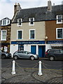
1
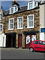
39 Shore Street, Anstruther Easter
Rebuilt in 1883, as per the stone above the ground floor doorway lintel, but probably on the grounds of a much earlier house, and granted a Category C listing https://britishlistedbuildings.co.uk/200380882-37-38-39-shore-street-anstruther-easter-including-garden-walls-east-neuk-and-landward-ward#.W5DF4OhKhPY in 1972. The listing extends to numbers 37 & 38 to the left, and also includes the garden walls at the rear.
Image: © Richard Law
Taken: 18 May 2018
0.01 miles
2
Dervish
A Turkish takeaway on Shore Street, Anstruther.
Image: © Richard Sutcliffe
Taken: 26 Sep 2024
0.01 miles
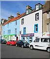
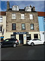
3
31 - 33 Shore Street, Anstruther Easter
A terrace of late 17th or early 18th century houses, which attracted a collective Category C listing https://britishlistedbuildings.co.uk/200380877-31-32-and-33-shore-street-anstruther-easter-including-rear-buildings-and-garden-walls-east-neuk-and-landward-ward#.W_csAtSLTGg in 1972; the listing includes some rear outbuildings and the garden walls.
Image: © Richard Law
Taken: 4 Oct 2018
0.01 miles
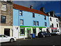
4
37 & 38 Shore Street, Anstruther Easter
Rebuilt in the 1880s, and similar in style to the adjoining Image, nos 37 & 38 were Category C listed https://britishlistedbuildings.co.uk/200380881-37-38-39-shore-street-anstruther-easter-including-garden-walls-east-neuk-and-landward-ward#.W_fYudSLTGg in 1972.
Image: © Richard Law
Taken: 4 Oct 2018
0.02 miles
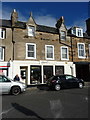
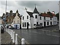
5
41 Shore Street, Anstruther Easter
No 41, along with the rest of the row to its right containing the much-photographed Image (nos 42, 43, 44) is essentially a 17th century town house that has been refronted and shop premises inserted on the ground floor. It was Category B listed in 1972.
Image: © Richard Law
Taken: 4 Oct 2018
0.02 miles
7
The Boathouse Bistro & Coffee Bar at 29/30 Shore Street
Occupying the former nos 29 & 30 (and more recently extended into no 28 to the left) The Boathouse is an early 19th century town house which was Category B listed https://britishlistedbuildings.co.uk/200380876-29-and-30-shore-street-anstruther-easter-including-rear-buildings-and-garden-walls-east-neuk-and-landward-ward#.W_cqINSLTGg in 1972.
Image: © Richard Law
Taken: 4 Oct 2018
0.02 miles
8
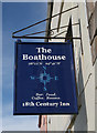
Sign for the Boathouse
The inn is on Shore Street, Anstruther Easter. The latitude and longditude are correct.
Image: © Richard Sutcliffe
Taken: 17 Mar 2019
0.02 miles
9
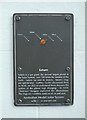
Anstruther Model Solar System: Saturn
On the wall of T.K. Brown (chemist) on Shore Street.
Image: © Richard Sutcliffe
Taken: 27 Sep 2019
0.02 miles
10
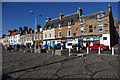
Shore Street, Anstruther
Anstruther Fish Bar is near the eastern end.
Image: © Ian Taylor
Taken: 30 Sep 2012
0.02 miles