1
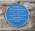
Blue plaque commemorating Princess Titaua Marama
The plaque is on the wall beside the gate to Johnstone Lodge [https://www.geograph.org.uk/photo/6118004]. It reads:
Princess
Titaua Marama
Chiefess of Haapiti
lived here
with her second husband
George Darsie
from 1892 until her death
in 1898
Anstruther Improvements Association
Image: © Richard Sutcliffe
Taken: 22 Mar 2019
0.01 miles
2
Blue Plaque, Johnston Lodge
This blue plaque set into a wall at Johnston Lodge reads: Princess Titaua Marama, Chiefess of Haapiti lived here with her second husband George Darsie from 1892 until her death in 1898 (Anstruther Improvements Association).
Image: © Mark Anderson
Taken: 1 Sep 2020
0.01 miles
3
Johnston Lodge
A closer view of the blue plaque can be seen here:
Image
Image: © Mark Anderson
Taken: 1 Sep 2020
0.01 miles
4
Johnstone Lodge, Anstruther Easter
This Category B listed building [http://portal.historicenvironment.scot/designation/LB36075] was the home of George Darsie (1841-1919) and his wife Tetuanuireiaiteruiate, the Princess Titaua Marama (1842-98) of Haapiti, Tahiti [http://scotfishmuseum.org/perch/resources/princess-titaua-marama.pdf]. A blue plaque beside the gate commemorates this.
Image: © Richard Sutcliffe
Taken: 22 Mar 2019
0.01 miles
5
The Ship Tavern at Anstruther
Image: © M J Richardson
Taken: 22 Jun 2009
0.02 miles
6
1 Haddfoot Wynd, Anstruther Easter
Dating from the late 18th century, and substantially renovated in 1960, 1 Haddfoot Wynd was Category C listed https://britishlistedbuildings.co.uk/200380892-1-haddfoot-wynd-anstruther-easter-kilrenny#.YoPkX-jMLIU in 1972, and the name of the former resident Miss Graham is preserved in the listing details.
Image: © Richard Law
Taken: 6 May 2022
0.02 miles
7
1 Haddfoot Wynd, Anstruther Easter
A late 18th century house, which is Category C listed.
Image: © Richard Sutcliffe
Taken: 22 Mar 2019
0.03 miles
8
39 Shore Street, Anstruther Easter
Rebuilt in 1883, as per the stone above the ground floor doorway lintel, but probably on the grounds of a much earlier house, and granted a Category C listing https://britishlistedbuildings.co.uk/200380882-37-38-39-shore-street-anstruther-easter-including-garden-walls-east-neuk-and-landward-ward#.W5DF4OhKhPY in 1972. The listing extends to numbers 37 & 38 to the left, and also includes the garden walls at the rear.
Image: © Richard Law
Taken: 18 May 2018
0.03 miles
9
Sea View / Hadfoot, Anstruther Easter
A very well kept, 17th century cottage on Haddfoot Wynd, with a Category B listing https://britishlistedbuildings.co.uk/200380890-sea-view-a-d-wylie-haddfoot-wynd-anstruther-easter-kilrenny#.XT2_LuhKjcs from 1972.
Image: © Richard Law
Taken: 6 Jun 2019
0.03 miles
10
Anstruther Fish Bar
The famous fish bar in Anstruther
Image: © edward mcmaihin
Taken: 9 Sep 2012
0.03 miles


