IMAGES TAKEN NEAR TO
Pittenweem, ANSTRUTHER, KY10 2RY
Introduction
This page details the photographs taken nearby to KY10 2RY by members of the Geograph project.
The Geograph project started in 2005 with the aim of publishing, organising and preserving representative images for every square kilometre of Great Britain, Ireland and the Isle of Man.

There are currently over 7.5m images from over14,400 individuals and you can help contribute to the project by visiting https://www.geograph.org.uk
Image Map
Images are licensed for reuse under creativecommons.org/licenses/by-sa/2.0
Notes
- Clicking on the map will re-center to the selected point.
- The higher the marker number, the further away the image location is from the centre of the postcode.
Image Listing (6 Images Found)
Images are licensed for reuse under creativecommons.org/licenses/by-sa/2.0
Image
Details
Distance
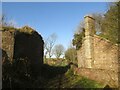
1
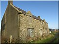
North Baldutho farmstead
Now deserted and virtually a ruin, a newer property is under construction to the north.
Image: © Becky Williamson
Taken: 21 Nov 2020
0.02 miles
2
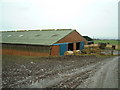
Byre and Bales
A cattle byre at North Baldutho Farm with bales of straw scattered in front of it
Image: © James Allan
Taken: 14 Feb 2006
0.03 miles
3
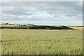
North Baldutho
From the Cunner Law - Baldutho Crag ridge looking North.
Image: © Jim Bain
Taken: 13 Jul 2006
0.20 miles
4
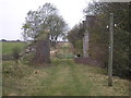
Farm track to dismantled railway bridge
The view of a farm track which leads to the dismantled bridge which once carried the East Fife Central Railway from near Leven to Lochty. The line was only used for freight and closed in 1964. More details at http://www.railbrit.co.uk/East_Fife_Central_Railway/frame.htm
Image: © Sandy Gemmill
Taken: 20 Oct 2011
0.24 miles
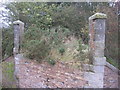
5
Remains of old railway bridge near North Baldutho
Part of the East Fife Central Railway.
Image: © Becky Williamson
Taken: 21 Nov 2020
0.24 miles
6
Dismantled railway bridge
The view of the dismantled railway line as seen from the western side of the dismantled bridge Image
Image: © Sandy Gemmill
Taken: 20 Oct 2011
0.25 miles