IMAGES TAKEN NEAR TO
High Street, ANSTRUTHER, KY10 2PL
Introduction
This page details the photographs taken nearby to High Street, KY10 2PL by members of the Geograph project.
The Geograph project started in 2005 with the aim of publishing, organising and preserving representative images for every square kilometre of Great Britain, Ireland and the Isle of Man.

There are currently over 7.5m images from over14,400 individuals and you can help contribute to the project by visiting https://www.geograph.org.uk
Image Map
Images are licensed for reuse under creativecommons.org/licenses/by-sa/2.0
Notes
- Clicking on the map will re-center to the selected point.
- The higher the marker number, the further away the image location is from the centre of the postcode.
Image Listing (500 Images Found)
Images are licensed for reuse under creativecommons.org/licenses/by-sa/2.0
Image
Details
Distance
1
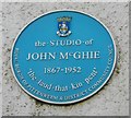
Blue plaque commemorating John McGhie
The plaque on the wall of 54 High Street reads:
The STUDIO of
JOHN McGHIE
1867-1952
'the laud that kin pent
Royal Burgh of Pittenweem & District Community Council
For information on John McGhie, see [http://www.howgill-tattershall.co.uk/modern-british-artists-l-to-o/john-mcghie/rocky-shore-pittenweem-from-howgill-tattershall-fine-art/introduction-to-artist-john-mcghie]
Image: © Richard Sutcliffe
Taken: 21 Mar 2019
0.00 miles
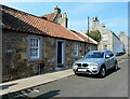
2
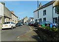
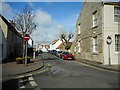
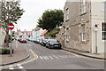
High Street, Pittenweem
Most of the properties on High Street are listed buildings.
Image: © Richard Sutcliffe
Taken: 11 Jun 2023
0.01 miles
4
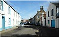
54 High Street, Pittenweem
The warehouse on the left was once the studio of artist John McGhie, and is commemorated by a blue plaque [https://www.geograph.org.uk/photo/6116339]. The house next door is a Category B listed building.
Image: © Richard Sutcliffe
Taken: 21 Mar 2019
0.01 miles
5
Cottage on High Street
Early-19th century cottage at the corner of High Street and South Loan. It is Category C listed https://portal.historicenvironment.scot/designation/LB39913.
Image: © Richard Sutcliffe
Taken: 11 Jun 2023
0.01 miles
6
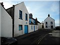
House on High Street
18th century Category B listed https://portal.historicenvironment.scot/designation/LB39926 property on High Street.
Image: © Richard Sutcliffe
Taken: 11 Jun 2023
0.02 miles
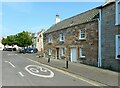
7
Routine Row, Pittenweem
Looking west along Routine Row from around the midway mark. Despite appearances this is one of the village's more important streets giving access to the health centre and other council buildings. It's one way and so narrow there is no need for yellow lines!
Image: © Jim Bain
Taken: 28 May 2006
0.03 miles
8
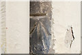
Cut Bench Mark, 49 High Street, Pittenweem
Bench Mark Database: https://www.bench-marks.org.uk/bm132640
Image: © Mark Anderson
Taken: 1 Sep 2020
0.03 miles
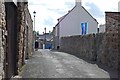
9
South Loan, Pittenweem
A one-way street.
Image: © Richard Sutcliffe
Taken: 21 Mar 2019
0.03 miles
10
South Loan, Pittenweem
Viewed from the High Street. There is a cut bench mark on the corner of the building to the right of the photograph and a closer view can be seen here: Image
Image: © Mark Anderson
Taken: 1 Sep 2020
0.03 miles