IMAGES TAKEN NEAR TO
Calmans Wynd, ANSTRUTHER, KY10 2NS

Introduction

This page details the photographs taken nearby to Calmans Wynd, KY10 2NS by members of the Geograph project.

The Geograph project started in 2005 with the aim of publishing, organising and preserving representative images for every square kilometre of Great Britain, Ireland and the Isle of Man.

There are currently over 7.5m images from over14,400 individuals and you can help contribute to the project by visiting https://www.geograph.org.uk

Image Map


Images are licensed for reuse under creativecommons.org/licenses/by-sa/2.0
Notes
  • Clicking on the map will re-center to the selected point.
  • The higher the marker number, the further away the image location is from the centre of the postcode.

Image Listing (490 Images Found)

Images are licensed for reuse under creativecommons.org/licenses/by-sa/2.0
  • ...
Image
Details
Distance
1
House with a blue plaque
8 Calman's Wynd, Pittenweem was the home of James More Horsburgh (1924-2007) Image It is a Category B listed building http://portal.historicenvironment.scot/designation/LB40035.
Image: © Richard Sutcliffe Taken: 29 Oct 2020
0.01 miles
2
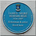
Blue plaque
At 8 Calman's Wynd, Pittenweem. It reads: James . More Horsburgh 1924-2007 fisherman & artist lived here ROYAL BURGH OF PITTENWEEM & DISTRICT COMMUNITY COUNCIL
Image: © Richard Sutcliffe Taken: 29 Oct 2020
0.01 miles
3
High Street, Pittenweem
Looking east from about midway down the street.
Image: © Jim Bain Taken: 28 May 2006
0.02 miles
4
Pittenweem Harbour
The west harbour looking east.
Image: © Jim Bain Taken: 28 May 2006
0.02 miles
5
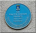
Blue plaque at 37 Mid Shore, Pittenweem
The plaque reads: SIR WALTER WATSON HUGHES 1803-1887 lived here 'father of the university of adelaide' ROYAL BURGH OF PITTENWEEM & DISTRICT COMMUNITY COUNCIL
Image: © Richard Sutcliffe Taken: 24 Sep 2019
0.02 miles
6
Houses, Mid Shore, Pittenweem
Category C listed buildings. The house on the right has a blue plaque commemorating Sir Walter Watson Hughes.
Image: © Richard Sutcliffe Taken: 24 Sep 2019
0.02 miles
7
Pittenweem from the Fife Coast path
Taken from the Fife Coast Path west of Pittenweem.
Image: © Becky Williamson Taken: 3 Nov 2019
0.02 miles
8
1 West Shore, Pittenweem
No 1 West Shore is a late 18th century fisherman's house, which was Category B listed https://britishlistedbuildings.co.uk/200385920-1-west-shore-including-garage-and-gear-shed-east-neuk-and-landward-ward#.W4vJP9QrLGg in 1972. The listing includes the lean-to gear shed seen here on the right, and the former detached gear shed just visible on the left.
Image: © Richard Law Taken: 18 May 2018
0.03 miles
9
Mid Shore, Pittenweem
Image: © Andrew Curtis Taken: 21 Aug 2019
0.03 miles
10
Houses on Mid Shore, Pittenweem
Image: © Richard Sutcliffe Taken: 24 Sep 2019
0.03 miles
  • ...