IMAGES TAKEN NEAR TO
DUNBEATH, KW6 6ET
Introduction
This page details the photographs taken nearby to KW6 6ET by members of the Geograph project.
The Geograph project started in 2005 with the aim of publishing, organising and preserving representative images for every square kilometre of Great Britain, Ireland and the Isle of Man.

There are currently over 7.5m images from over14,400 individuals and you can help contribute to the project by visiting https://www.geograph.org.uk
Image Map
Images are licensed for reuse under creativecommons.org/licenses/by-sa/2.0
Notes
- Clicking on the map will re-center to the selected point.
- The higher the marker number, the further away the image location is from the centre of the postcode.
Image Listing (12 Images Found)
Images are licensed for reuse under creativecommons.org/licenses/by-sa/2.0
Image
Details
Distance
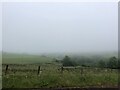
2
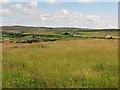
Hay meadow near Dunbeath
A field by Blackburn with a view northwards towards Beinn-a-chielt.
Image: © Richard Webb
Taken: 23 Jul 2010
0.15 miles
3
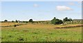
Hay meadows, Blackburn
Croft land near Dunbeath.
Image: © Richard Webb
Taken: 23 Jul 2010
0.16 miles
4
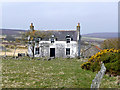
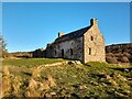
Abandoned house
If you fancy a challenge, try renovating this property west of Dunbeath.
Image: © Jonathan Billinger
Taken: 23 Apr 2008
0.17 miles
5
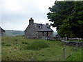
Former Inn at Milton
At one time an inn with the name suggesting possibly a mill in earlier times.
Image: © David Bremner
Taken: 2 Apr 2022
0.19 miles
6
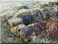
Old Well at Millton
This well was dry when visited.
Image: © David Bremner
Taken: 27 Mar 2021
0.20 miles
7
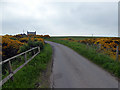
Dunbeath road at Blackburn
Crossing Blackburn
Image: © John Lucas
Taken: 31 May 2018
0.21 miles
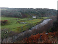
10
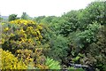
Black Burn, Dunbeath
Down there in the jungle.
Image: © Richard Webb
Taken: 29 Jun 2015
0.23 miles