IMAGES TAKEN NEAR TO
DUNBEATH, KW6 6EJ
Introduction
This page details the photographs taken nearby to KW6 6EJ by members of the Geograph project.
The Geograph project started in 2005 with the aim of publishing, organising and preserving representative images for every square kilometre of Great Britain, Ireland and the Isle of Man.

There are currently over 7.5m images from over14,400 individuals and you can help contribute to the project by visiting https://www.geograph.org.uk
Image Map
Images are licensed for reuse under creativecommons.org/licenses/by-sa/2.0
Notes
- Clicking on the map will re-center to the selected point.
- The higher the marker number, the further away the image location is from the centre of the postcode.
Image Listing (3 Images Found)
Images are licensed for reuse under creativecommons.org/licenses/by-sa/2.0
Image
Details
Distance
1
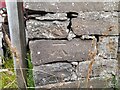
OS Benchmark near Dunbeath
A cut mark on garages/ workshops near Dunbeath.
Image: © David Bremner
Taken: 28 Aug 2022
0.19 miles
2
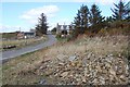
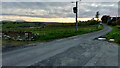
Markethill above Dunbeath
Just off the A9 on the Houstry road lies this small collection of houses and some industrial units.
Image: © Jim Bain
Taken: 23 Apr 2006
0.22 miles