IMAGES TAKEN NEAR TO
Harray, ORKNEY, KW17 2JS
Introduction
This page details the photographs taken nearby to KW17 2JS by members of the Geograph project.
The Geograph project started in 2005 with the aim of publishing, organising and preserving representative images for every square kilometre of Great Britain, Ireland and the Isle of Man.

There are currently over 7.5m images from over14,400 individuals and you can help contribute to the project by visiting https://www.geograph.org.uk
Image Map (Loading...)


Getting Data...Please wait
Leaflet Map data © OpenStreetMap
Images are licensed for reuse under creativecommons.org/licenses/by-sa/2.0
Notes
- Clicking on the map will re-center to the selected point.
- The higher the marker number, the further away the image location is from the centre of the postcode.
Image Listing (11 Images Found)
Images are licensed for reuse under creativecommons.org/licenses/by-sa/2.0
Image
Details
Distance
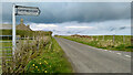
2
Staney Hill road towards Buckquoy
Looking south west down a gentle hill with Loch of Harray in the distance and the hills of Hoy on the horizon.
Image: © Gordon Hatton
Taken: 15 Jun 2021
0.05 miles
3
Staney Hill Standing Stone
“Staney Hill | Canmore.” 2021. Canmore.org.uk [accessed 7 June 2021]
Image: © Mick Garratt
Taken: 17 May 2021
0.12 miles
4
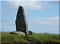
Staney Hill Standing Stone
The eight-foot-tall stone stands not far from the road. It is said to have been erected during St Magnus' funeral procession. See https://canmore.org.uk/site/2000/staney-hill for further details.
Image: © Anne Burgess
Taken: 15 Jun 2018
0.12 miles
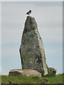
5
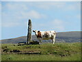
The ideal rubbing post
Just for a change there is no oystercatcher or wheatear standing on top of the standing stone at Staney Hill, but the cattle in the field find it an ideal rubbing post.
Image: © Gordon Hatton
Taken: 22 Jun 2021
0.13 miles
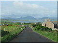
6
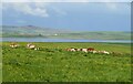
Cattle in the sun
Cattle in lush pastures near Staney Hill with the Harray Loch in the distance.
Image: © Gordon Hatton
Taken: 15 Jun 2021
0.16 miles
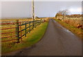
8
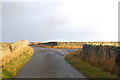
Lane to Nearhouse
Looking NNW. Straight on to Stanley Hill. As I took the photo I could hear the sound of the hail getting closer.
Image: © Ian Balcombe
Taken: 18 Dec 2008
0.21 miles
9
Looking toward the lane junction.
Looking westwards.
Image: © Ian Balcombe
Taken: 18 Dec 2008
0.22 miles
10
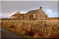
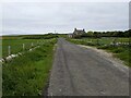
Converted Chapel
Looking NW from the lane to Nearhouse.
Image: © Ian Balcombe
Taken: 18 Dec 2008
0.23 miles