IMAGES TAKEN NEAR TO
Twatt, ORKNEY, KW17 2JG
Introduction
This page details the photographs taken nearby to KW17 2JG by members of the Geograph project.
The Geograph project started in 2005 with the aim of publishing, organising and preserving representative images for every square kilometre of Great Britain, Ireland and the Isle of Man.

There are currently over 7.5m images from over14,400 individuals and you can help contribute to the project by visiting https://www.geograph.org.uk
Image Map (Loading...)


Getting Data...Please wait
Leaflet Map data © OpenStreetMap
Images are licensed for reuse under creativecommons.org/licenses/by-sa/2.0
Notes
- Clicking on the map will re-center to the selected point.
- The higher the marker number, the further away the image location is from the centre of the postcode.
Image Listing (2 Images Found)
Images are licensed for reuse under creativecommons.org/licenses/by-sa/2.0
Image
Details
Distance
1
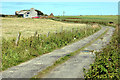
The farm of Nether Linklater in Sandwick
Photographed from the Quoyloo road.
Image: © John Comloquoy
Taken: 9 Aug 2007
0.01 miles
2

Cattle near Newhall
Like cattle everywhere, these Orcadian ones are inquisitive, and coming over to have a look at me. Fortunately a headwater of the Burn of Clett lies between them and me.
Image: © Anne Burgess
Taken: 15 Jun 2018
0.20 miles