IMAGES TAKEN NEAR TO
Finstown, ORKNEY, KW17 2ES
Introduction
This page details the photographs taken nearby to KW17 2ES by members of the Geograph project.
The Geograph project started in 2005 with the aim of publishing, organising and preserving representative images for every square kilometre of Great Britain, Ireland and the Isle of Man.

There are currently over 7.5m images from over14,400 individuals and you can help contribute to the project by visiting https://www.geograph.org.uk
Image Map
Images are licensed for reuse under creativecommons.org/licenses/by-sa/2.0
Notes
- Clicking on the map will re-center to the selected point.
- The higher the marker number, the further away the image location is from the centre of the postcode.
Image Listing (9 Images Found)
Images are licensed for reuse under creativecommons.org/licenses/by-sa/2.0
Image
Details
Distance
1
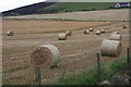
Hay bales at Horraldshay
Hay bales in a field next to Horraldshay.
Image: © Colin Kinnear
Taken: 11 Sep 2010
0.15 miles
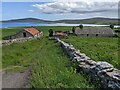
2
Buildings at Horraldshay
In varying states of repair - some roofs are missing.
Image: © David Medcalf
Taken: 10 Jun 2022
0.19 miles
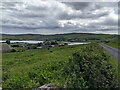
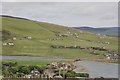
3
The lane to Horraldshay
Looking out to the Bay of Firth, with the island Holm of Grimbister in the middle.
Image: © David Medcalf
Taken: 10 Jun 2022
0.20 miles
4
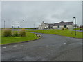
Firth primary school
On the outskirts of Finstown.
Image: © James Allan
Taken: 14 May 2017
0.22 miles
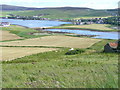
5
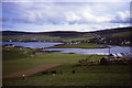
Looking towards The Ouse and A966 bridge from Horraldshay
Image: © Colin Park
Taken: 23 May 1985
0.23 miles
6
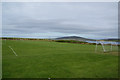
Football ground at Finstown
I think the main club using this is currently Firth FC.
Image: © Bill Boaden
Taken: 6 Aug 2013
0.24 miles
7
Finstown school on the north waterfront
The view is from Finstown Centre waterfront. This photo was cropped out of Image
Image: © C Michael Hogan
Taken: 9 Jul 2007
0.24 miles
9
Bridge and The Ouse, Finstown
The old stone bridge carrying the road north to Tingwall divides the Bay of Firth from the tidal Ouse.
Image: © Colin Smith
Taken: 27 Jun 2007
0.25 miles