IMAGES TAKEN NEAR TO
Finstown, ORKNEY, KW17 2EJ
Introduction
This page details the photographs taken nearby to KW17 2EJ by members of the Geograph project.
The Geograph project started in 2005 with the aim of publishing, organising and preserving representative images for every square kilometre of Great Britain, Ireland and the Isle of Man.

There are currently over 7.5m images from over14,400 individuals and you can help contribute to the project by visiting https://www.geograph.org.uk
Image Map
Images are licensed for reuse under creativecommons.org/licenses/by-sa/2.0
Notes
- Clicking on the map will re-center to the selected point.
- The higher the marker number, the further away the image location is from the centre of the postcode.
Image Listing (13 Images Found)
Images are licensed for reuse under creativecommons.org/licenses/by-sa/2.0
Image
Details
Distance
1
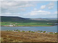
Bay of Firth from the chambered cairn at Cuween Hill
Taken at 1.00pm on 28th May 2019
Image: © Douglas Thomson
Taken: 29 May 2019
0.09 miles
2
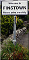
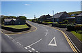
Finstown
Named after the Irishman who opened a pub at this junction of major roads on mainland Orkney, Finstown is still a significant crossing-point between east, west and north mainland.
Image: © David Wyatt
Taken: Unknown
0.10 miles
5
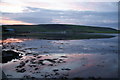
Bay of Firth
Viewed in evening light. Finstown is to the left and its disused pier is visible projecting from the left.
Image: © Bill Boaden
Taken: 6 Aug 2013
0.19 miles
8
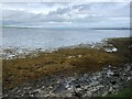
Shoreline of Bay of Firth
Near Finstown.
Image: © James Allan
Taken: 9 May 2017
0.21 miles