IMAGES TAKEN NEAR TO
Sanday, ORKNEY, KW17 2BL
Introduction
This page details the photographs taken nearby to KW17 2BL by members of the Geograph project.
The Geograph project started in 2005 with the aim of publishing, organising and preserving representative images for every square kilometre of Great Britain, Ireland and the Isle of Man.

There are currently over 7.5m images from over14,400 individuals and you can help contribute to the project by visiting https://www.geograph.org.uk
Image Map (Loading...)


Getting Data...Please wait
Leaflet Map data © OpenStreetMap
Images are licensed for reuse under creativecommons.org/licenses/by-sa/2.0
Notes
- Clicking on the map will re-center to the selected point.
- The higher the marker number, the further away the image location is from the centre of the postcode.
Image Listing (4 Images Found)
Images are licensed for reuse under creativecommons.org/licenses/by-sa/2.0
Image
Details
Distance
1
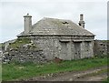
Ruined lodge
This is the lodge to the large ruined house of Geramount. It has octagonal ends.
Image: © Rob Burke
Taken: 19 May 2006
0.18 miles
3
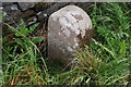
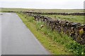
Old Milestone by the B9069, Lady Kirkyard, Lady parish
Stone post by the B9069, in parish of Lady (Sanday District), near cemetery and track to Els Ness, in front of stone wall.
Inscription reads:-
: K / 2 : : L / 6½ :
(To Kettletoft and Lady)
Surveyed
Milestone Society National ID: OR_SNKL02
Image: © Milestone Society
Taken: Unknown
0.24 miles
4
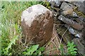
Milestone, Orkney - Sanday
Facing L 6 1/2 (Lady) and rear K 2 (Kettletoft)
Image: © Andrew Riley
Taken: 20 Jun 2008
0.24 miles