IMAGES TAKEN NEAR TO
Sanday, ORKNEY, KW17 2AY
Introduction
This page details the photographs taken nearby to KW17 2AY by members of the Geograph project.
The Geograph project started in 2005 with the aim of publishing, organising and preserving representative images for every square kilometre of Great Britain, Ireland and the Isle of Man.

There are currently over 7.5m images from over14,400 individuals and you can help contribute to the project by visiting https://www.geograph.org.uk
Image Map
Images are licensed for reuse under creativecommons.org/licenses/by-sa/2.0
Notes
- Clicking on the map will re-center to the selected point.
- The higher the marker number, the further away the image location is from the centre of the postcode.
Image Listing (2 Images Found)
Images are licensed for reuse under creativecommons.org/licenses/by-sa/2.0
Image
Details
Distance
1
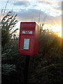
Sanday: postbox № KW17 78, Quivals
This postbox is of a modern design, constructed of pressed steel and designed to be more robust, rustproof and theft-proof than the traditional cast iron box that it will have replaced in the last couple of years.
This particular style of box is becoming quite commonplace in these remote, exposed parts.
There was a post office named Quivals from 11 April 1898 to 30 July 2003, one of five post offices on the island from the 1940s to the '70s. Some maps located it about half a mile north of here, but perhaps its last location was the house which has this box at the end of the drive.
Image: © Chris Downer
Taken: 4 Aug 2015
0.16 miles