IMAGES TAKEN NEAR TO
Stronsay, ORKNEY, KW17 2AG
Introduction
This page details the photographs taken nearby to KW17 2AG by members of the Geograph project.
The Geograph project started in 2005 with the aim of publishing, organising and preserving representative images for every square kilometre of Great Britain, Ireland and the Isle of Man.

There are currently over 7.5m images from over14,400 individuals and you can help contribute to the project by visiting https://www.geograph.org.uk
Image Map (Loading...)


Getting Data...Please wait
Leaflet Map data © OpenStreetMap
Images are licensed for reuse under creativecommons.org/licenses/by-sa/2.0
Notes
- Clicking on the map will re-center to the selected point.
- The higher the marker number, the further away the image location is from the centre of the postcode.
Image Listing (3 Images Found)
Images are licensed for reuse under creativecommons.org/licenses/by-sa/2.0
Image
Details
Distance
1
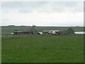
Kirkhall, Stronsay
Meikle Water is in the background.
Image: © Rob Burke
Taken: 17 May 2006
0.19 miles
2
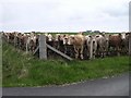
Young bullocks on Stronsay
One of many fields containing young bullocks who were inquisitive about everything that happened nearby. Having made sure they all got a good view of the two people walking past on the road, they then kept pace with us till we were past the top of their field.
Image: © Lis Burke
Taken: 17 May 2006
0.19 miles
3
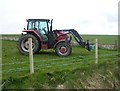
New fencing on Stronsay
Green-coated barbed wire is being used to make a new fence.
Image: © Lis Burke
Taken: 17 May 2006
0.24 miles