IMAGES TAKEN NEAR TO
Stenness, STROMNESS, KW16 3HH
Introduction
This page details the photographs taken nearby to KW16 3HH by members of the Geograph project.
The Geograph project started in 2005 with the aim of publishing, organising and preserving representative images for every square kilometre of Great Britain, Ireland and the Isle of Man.

There are currently over 7.5m images from over14,400 individuals and you can help contribute to the project by visiting https://www.geograph.org.uk
Image Map (Loading...)


Getting Data...Please wait
Leaflet Map data © OpenStreetMap
Images are licensed for reuse under creativecommons.org/licenses/by-sa/2.0
Notes
- Clicking on the map will re-center to the selected point.
- The higher the marker number, the further away the image location is from the centre of the postcode.
Image Listing (2 Images Found)
Images are licensed for reuse under creativecommons.org/licenses/by-sa/2.0
Image
Details
Distance
1
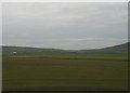
Buildings to the south east of Maes Howe
Taken from top of Maes Howe
Image: © Alan Douiglas
Taken: 10 Apr 2003
0.01 miles
2
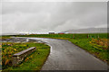
Quoyamoan
Track to the farm off the A965 crosses the Burn of Heddle at this point.
Image: © Andy Farrington
Taken: 15 May 2013
0.23 miles