IMAGES TAKEN NEAR TO
Pumpwell Park, STROMNESS, KW16 3EA
Introduction
This page details the photographs taken nearby to Pumpwell Park, KW16 3EA by members of the Geograph project.
The Geograph project started in 2005 with the aim of publishing, organising and preserving representative images for every square kilometre of Great Britain, Ireland and the Isle of Man.

There are currently over 7.5m images from over14,400 individuals and you can help contribute to the project by visiting https://www.geograph.org.uk
Image Map (Loading...)


Getting Data...Please wait
Leaflet Map data © OpenStreetMap
Images are licensed for reuse under creativecommons.org/licenses/by-sa/2.0
Notes
- Clicking on the map will re-center to the selected point.
- The higher the marker number, the further away the image location is from the centre of the postcode.
Image Listing (305 Images Found)
Images are licensed for reuse under creativecommons.org/licenses/by-sa/2.0
Image
Details
Distance
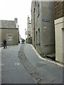
1
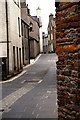
Stromness, Orkney Islands
The main thoroughfare
Image: © Malcolm Morris
Taken: 11 Jul 2008
0.05 miles

4
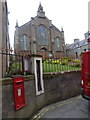
Stromness: parish church, postbox and barometer
A postbox and barometer are set into the wall at the front of the churchyard in Victoria Street, outside which are three rare parking spots in this narrow road.
The postbox and barometer can be seen in closer detail here: Image
Image: © Chris Downer
Taken: 26 Jul 2011
0.05 miles
5
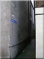
Khyber Pass
Not quite on the scale of the original!
Image: © John Lucas
Taken: 15 Nov 2011
0.05 miles
7
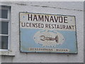
Hamnavoe Licensed Restaurant sign
Image: © Nick Mutton 01329 000000
Taken: 18 Aug 2008
0.05 miles
8
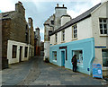
Dundas Street, Stromness
Ahead is Graham Place with Leslie's Close to the right.
Image: © Andy Farrington
Taken: 16 May 2013
0.05 miles
9
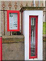
Fitzroy Fisheries Barometer
Admiral Robert Fitzroy (1805 -1865) devised the Fishery Barometer in 1857 and instituted a network of about 100 barometers located around the coast of Britain for recording pressure and warning of imminent storms. This barometer, sited in Victoria Street Stromness, is number 98 in the network and was still in regular use until about 2005.
Image: © Oliver Dixon
Taken: 3 May 2015
0.05 miles
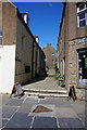
10
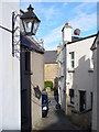
Leslie's Close
A narrow Stromness pend descending to Graham Street, a length of the town's main street. On the left is a high class fish restaurant. The old house in the distance has its red sandstone walls showing.
Image: © Colin Smith
Taken: 17 Jun 2007
0.05 miles