IMAGES TAKEN NEAR TO
Grieveship Road, STROMNESS, KW16 3AZ
Introduction
This page details the photographs taken nearby to Grieveship Road, KW16 3AZ by members of the Geograph project.
The Geograph project started in 2005 with the aim of publishing, organising and preserving representative images for every square kilometre of Great Britain, Ireland and the Isle of Man.

There are currently over 7.5m images from over14,400 individuals and you can help contribute to the project by visiting https://www.geograph.org.uk
Image Map
Images are licensed for reuse under creativecommons.org/licenses/by-sa/2.0
Notes
- Clicking on the map will re-center to the selected point.
- The higher the marker number, the further away the image location is from the centre of the postcode.
Image Listing (205 Images Found)
Images are licensed for reuse under creativecommons.org/licenses/by-sa/2.0
Image
Details
Distance
1

Stromness: Royal Mail Delivery Office
The delivery office for the KW16 postcode area shares its building with a BT telephone exchange (out of shot to the right).
Image: © Chris Downer
Taken: 26 Jul 2011
0.06 miles
2
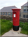
Stromness: postbox № KW16 3, Back Road
This large, modern pillar box faces the main entrance of the Image and it is therefore not surprising that it has the latest collection times in town - 2:15pm on weekdays and 1:15pm on Saturdays.
Image: © Chris Downer
Taken: 26 Jul 2011
0.07 miles
3
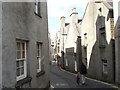
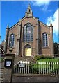
Stromness gables
Hamnavoe - Wonderful place made all the better with a knowledge of George Mackay Brown's poetry. Fantastic museum at the end of the twisting narrow main streets also. The houses were built gable on the sea front to protect them and they had their own landing jettys many of which are still there.
Image: © Gus Macdonald
Taken: 21 May 2007
0.08 miles
4
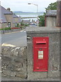
Stromness: postbox № KW16 16, Back Road
This Elizabeth II-reign wall box has its back to Springfield Crescent and a view across the western end of Scapa Flow. It is emptied finally at 1pm on weekdays and at 11:30am on Saturdays.
Image: © Chris Downer
Taken: 26 Jul 2011
0.10 miles
6
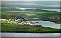
View from the Sofa Stone, Stromness, Ornkey
Taken from Brinkies Brae while sitting on the sofa stone, a large rock, comfortable for sitting on which is shaped like, well, a sofa.
Looking towards Stromness harbour which lies within the grid square.
Image: © Claire Pegrum
Taken: 2 Sep 2019
0.13 miles
9
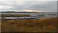
Stromness and Hamnavoe seen from Ward Hill, Hoy
The photograph was taken from near the summit cairn on Ward Hill. The stretch of water in the foreground is part of Hoy Sound. Just beyond Stromness are the two arms of the Loch of Stenness. The Loch of Harray lies beyond that in the distance.
Image: © Les Shaw
Taken: Unknown
0.13 miles
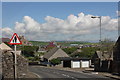
10
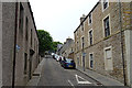
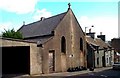
Church Road
This steep street must have been widened at some point from a vennel like Image Image] is on the right half-way up.
Image: © Anne Burgess
Taken: 9 Jun 2018
0.16 miles