IMAGES TAKEN NEAR TO
Upper Dunbar Street, WICK, KW1 5QH
Introduction
This page details the photographs taken nearby to Upper Dunbar Street, KW1 5QH by members of the Geograph project.
The Geograph project started in 2005 with the aim of publishing, organising and preserving representative images for every square kilometre of Great Britain, Ireland and the Isle of Man.

There are currently over 7.5m images from over14,400 individuals and you can help contribute to the project by visiting https://www.geograph.org.uk
Image Map
Images are licensed for reuse under creativecommons.org/licenses/by-sa/2.0
Notes
- Clicking on the map will re-center to the selected point.
- The higher the marker number, the further away the image location is from the centre of the postcode.
Image Listing (38 Images Found)
Images are licensed for reuse under creativecommons.org/licenses/by-sa/2.0
Image
Details
Distance
1
Argyle Square, Upper Pulteneytown, Caithness
Pulteneytown is a planned settlement developed by the British Fisheries Society in the early 19th century. Argyle Square is the centrepiece of Upper Pulteneytown, the residential zone.
Image: © Claire Pegrum
Taken: 31 Aug 2020
0.11 miles
2
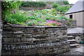
Wick Museum and Heritage Centre
To the rear outside is a beautifully tended garden supporting all sorts of interesting plants. This is due to the efforts of the volunteers who, as those on duty indoors, are so friendly and helpful. If in Wick do not hesitate to visit this worthwhile place.
Image: © Glen Breaden
Taken: 26 May 2011
0.12 miles
3
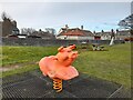
Play Equipment
Some new equipment including this springy piggy has recently been installed.
Image: © David Bremner
Taken: 18 Feb 2023
0.14 miles
4
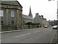
Malcolm Street approaching its junction with Dempster Street, Wick
Looking southward.
Image: © Peter Wood
Taken: 24 Jun 2022
0.14 miles
5
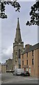
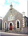
Wick Baptist Church, Wick, Caithness
Viewed from Argyle Square.
Located in Dempster Street in Pulteneytown, the church is also known as Wick Central Church. A listed building, it was built in 1853 and the spire was added in 1862. Previously it has been home to Free Church, United Free Church and Church of Scotland congregations. It was bought by Wick Baptist Church in 1997.
Image: © Claire Pegrum
Taken: 31 Aug 2020
0.15 miles
6
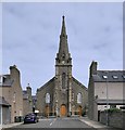
Wick Baptist Church, Wick, Caithness
Located in Dempster Street in Pulteneytown, the church is also known as Wick Central Church. A listed building, it was built in 1853 and the spire was added in 1862. Previously it has been home to Free Church, United Free Church and Church of Scotland congregations. It was bought by Wick Baptist Church in 1997.
Image: © Claire Pegrum
Taken: 31 Aug 2020
0.15 miles
8
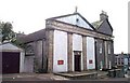
St. Joachim's Roman Catholic Church, Wick
Image: © Bill Henderson
Taken: Unknown
0.18 miles
9

1-4 MacArthur Place, Wick, Caithness
The building appears on the 2nd Edition OS map, but not on the 1st, and so was built sometime between 1872 and 1905 when the two maps were surveyed. A photo exists of it in the 1930s when it was a Co-operative store and this road junction was known as Co-op Corner: https://www.johnstoncollection.net/show_image.php?ind=JN20004B001 .
At the time of uploading, the building is empty and is on the Buildings at Risk Register for Scotland: https://www.buildingsatrisk.org.uk/details/926921 .
Image: © Claire Pegrum
Taken: 31 Aug 2020
0.18 miles
10
Associated Presbyterian Church, Breadalbane Terrace, Wick
Image: © Bill Henderson
Taken: Unknown
0.18 miles