IMAGES TAKEN NEAR TO
Barbara Place, WICK, KW1 5LQ
Introduction
This page details the photographs taken nearby to Barbara Place, KW1 5LQ by members of the Geograph project.
The Geograph project started in 2005 with the aim of publishing, organising and preserving representative images for every square kilometre of Great Britain, Ireland and the Isle of Man.

There are currently over 7.5m images from over14,400 individuals and you can help contribute to the project by visiting https://www.geograph.org.uk
Image Map
Images are licensed for reuse under creativecommons.org/licenses/by-sa/2.0
Notes
- Clicking on the map will re-center to the selected point.
- The higher the marker number, the further away the image location is from the centre of the postcode.
Image Listing (125 Images Found)
Images are licensed for reuse under creativecommons.org/licenses/by-sa/2.0
Image
Details
Distance
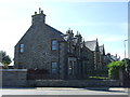
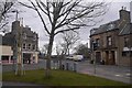
1
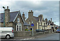
Newton Road
Traditional stone-built houses in Wick's Newton Road, viewed at the junction with Coronation Street.
Image: © Mary and Angus Hogg
Taken: 25 Oct 2014
0.05 miles
5
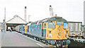
Wick station, with evening express to Inverness, 1984
Birmingham RC&W/Sulzer class 26 Type 2 Bo-Bo No. 26038 (built 8/59 as D5338, renumbered 31/12/73, withdrawn 19/10/92) is heading another Type 2 on the 18.00 Up express by the Far North Line. No. 26038 is one of many of the class that have been preserved, this one by the Bo'ness & Kinneil Railway, being given the name 'Tom Clift 1954-2012' following the death of its owner.
Image: © Walter Dendy, deceased
Taken: 5 Sep 1984
0.08 miles
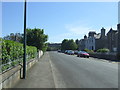
6
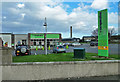
The Co-operative
The Co-op supermarket at Wick, viewed from Thurso Road.
Image: © Mary and Angus Hogg
Taken: 25 Oct 2014
0.08 miles
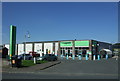
9
Junction, Pultneytown
View from a Wick filling station on what used to be the A9 before renumbering. This is the junction of Francis Street (left), Thurso Street (straight ahead past the red light), Cliff Road (with van) and Dempster Street(right).
Image: © Richard Webb
Taken: 7 Apr 2018
0.11 miles
