IMAGES TAKEN NEAR TO
Shilling Hill, WICK, KW1 5HY
Introduction
This page details the photographs taken nearby to Shilling Hill, KW1 5HY by members of the Geograph project.
The Geograph project started in 2005 with the aim of publishing, organising and preserving representative images for every square kilometre of Great Britain, Ireland and the Isle of Man.

There are currently over 7.5m images from over14,400 individuals and you can help contribute to the project by visiting https://www.geograph.org.uk
Image Map
Images are licensed for reuse under creativecommons.org/licenses/by-sa/2.0
Notes
- Clicking on the map will re-center to the selected point.
- The higher the marker number, the further away the image location is from the centre of the postcode.
Image Listing (7 Images Found)
Images are licensed for reuse under creativecommons.org/licenses/by-sa/2.0
Image
Details
Distance
1
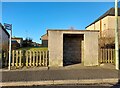
Bus Stop and Shelter, Wellington Avenue
Image: © David Bremner
Taken: 21 Apr 2021
0.11 miles

4
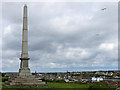
Monument to James Bremner, Wick
James Bremner (1784-1856) was a naval architect, ship builder, harbour builder and ship-raiser. The monument was erected in 1903 and overlooks Wick harbour.
Image: © wrobison
Taken: 28 Jun 2014
0.21 miles
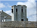
5

Ruined Breakwater
All that remains of the ill fated Stevenson built breakwater, which was destroyed in a storm before it was completed
Image: © John MacKenzie
Taken: 16 Jul 2012
0.23 miles
6

View over Wick Bay
From near the Coastguard Lookout, with a fishing boat entering harbour.
Image: © Stanley Howe
Taken: 26 Jun 2007
0.23 miles