IMAGES TAKEN NEAR TO
Miller Lane, WICK, KW1 5AP
Introduction
This page details the photographs taken nearby to Miller Lane, KW1 5AP by members of the Geograph project.
The Geograph project started in 2005 with the aim of publishing, organising and preserving representative images for every square kilometre of Great Britain, Ireland and the Isle of Man.

There are currently over 7.5m images from over14,400 individuals and you can help contribute to the project by visiting https://www.geograph.org.uk
Image Map
Images are licensed for reuse under creativecommons.org/licenses/by-sa/2.0
Notes
- Clicking on the map will re-center to the selected point.
- The higher the marker number, the further away the image location is from the centre of the postcode.
Image Listing (148 Images Found)
Images are licensed for reuse under creativecommons.org/licenses/by-sa/2.0
Image
Details
Distance
1
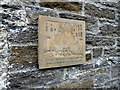
L.S. Lowry Commemorative Plaque, 'Black Steps', Wick
Commemorative plaque situated on the 'Black Steps' in Wick, painted by the British artist L.S. Lowry in 1936.
Image: © Alex Passmore
Taken: 5 Jun 2019
0.02 miles
3
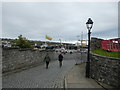
Bank Row, Wick, Caithness
This view shows the harbour end of Bank Row, the 'Black Steps' are to the right of the photograph.
The Black Steps were included in Thomas Telford's 1820 design for the development of the harbour area.
Image: © Alex Passmore
Taken: 5 Jun 2019
0.03 miles
4
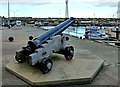
The Fog Cannon
The cannon was introduced to Wick in 1881 to give a navigation signal in foggy weather conditions. This development was undertaken after several shipping accidents with significant loss of life.
Image: © Mary and Angus Hogg
Taken: 25 Oct 2014
0.05 miles
5
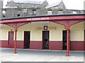
Wick Herring Mart
Built on the site of an earlier fishing market this is being / has been renovated
Image: © hayley green
Taken: 8 Jun 2008
0.05 miles
6
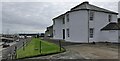
The Roundhouse, Harbour Place, Wick, Caithness
The Roundhouse is a category B listed building which overlooks Wick Harbour. It was built in 1807 for George Burn, a local contractor who constructed Wick Bridge, the inner harbour and houses in upper Pulteneytown. The design is by Thomas Telford and has a similar style to houses that Telford built along the Caledonian Canal at Banavie (Image) and Gairlochy (Image).
Image: © Claire Pegrum
Taken: 31 Aug 2020
0.05 miles
7
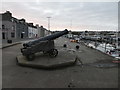
Fog cannon, Wick, Caithness
The cannon was presented by John Pender MP to the Pulteney Harbour Trust in 1881 to be used as a signal for boats.
Image: © Alex Passmore
Taken: 5 Jun 2019
0.05 miles
8
Wick heritage Centre
A great place to visit for education and local history.
Image: © John MacKenzie
Taken: 17 Mar 2011
0.06 miles
9
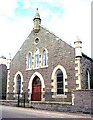
Associated Presbyterian Church, Breadalbane Terrace, Wick
Image: © Bill Henderson
Taken: Unknown
0.06 miles
10
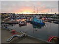
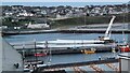
Marina & Inner Harbour, Wick, Caithness
Evening light on the Inner Harbour, Wick.
Image: © Alex Passmore
Taken: 5 Jun 2019
0.07 miles