IMAGES TAKEN NEAR TO
Logie Drive, KIRKWALL, KW15 1ZT
Introduction
This page details the photographs taken nearby to Logie Drive, KW15 1ZT by members of the Geograph project.
The Geograph project started in 2005 with the aim of publishing, organising and preserving representative images for every square kilometre of Great Britain, Ireland and the Isle of Man.

There are currently over 7.5m images from over14,400 individuals and you can help contribute to the project by visiting https://www.geograph.org.uk
Image Map
Images are licensed for reuse under creativecommons.org/licenses/by-sa/2.0
Notes
- Clicking on the map will re-center to the selected point.
- The higher the marker number, the further away the image location is from the centre of the postcode.
Image Listing (16 Images Found)
Images are licensed for reuse under creativecommons.org/licenses/by-sa/2.0
Image
Details
Distance
1
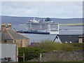
View from Berstane Road
The view from Berstane Road is dominated by the massive cruise liner MSC Splendida moored at Hatston Pier Image
Image: © Oliver Dixon
Taken: 8 May 2015
0.04 miles
2

Kirkwall: postbox № KW15 1, Berstane Road
An Elizabeth II-reign postbox of a design usually found on a wooden post or metal pole, but set into a wall on the southern side of Berstane Road. It is emptied finally at 2:15pm on weekdays and at 1:30pm on Saturdays.
Image: © Chris Downer
Taken: 28 Jul 2011
0.08 miles
3
The Hostel
This is where pupils at Kirkwall Grammar School, who live in the smaller isles, stay during the week. It is more like a university halls of residence than a "hostel".
Image: © Ian Balcombe
Taken: 13 Jan 2009
0.15 miles
4

Former fish curing house, East Road, Kirkwall, Orkney
The building has been converted to two residences. A photo of the building taken in 1976 (approximately 20 years before it was converted) is at https://canmore.org.uk/collection/461317 .
Image: © Claire Pegrum
Taken: 26 May 2022
0.17 miles
5
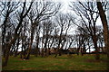
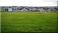
Mature woodland and farmbuildings, Kirkwall.
The town has grown and absorbed the farmbuildings within the suburbs.
Image: © Ian Balcombe
Taken: 13 Jan 2009
0.18 miles
6
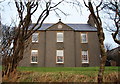
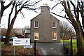
Papdale House
A stately building, now used as offices by Orkney Islands Council.
Image: © Ian Balcombe
Taken: 13 Jan 2009
0.18 miles
7

Kirkwall: postbox № KW15 12, Willowburn Road
An Elizabeth II-reign postbox of a design usually found on a wooden post or metal pole, but set into a wall on the western side of Willowburn Road. It is emptied finally at 2:15pm on weekdays and at 1:30pm on Saturdays.
Image: © Chris Downer
Taken: 28 Jul 2011
0.19 miles
8
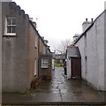
Rows off St Catherine's Place
Houses in Kirkwall with gable ends on to the street.
Image: © Richard Webb
Taken: 9 Apr 2018
0.20 miles
9
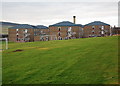
Papdale Primary School
Orkney is full of surprises. This is Scotland's largest primary school with about 500 pupils.
Image: © Ian Balcombe
Taken: 13 Jan 2009
0.20 miles
10
Papdale House
The entrance and car park.
Image: © Ian Balcombe
Taken: 13 Jan 2009
0.22 miles