IMAGES TAKEN NEAR TO
Wasdale Crescent, KIRKWALL, KW15 1YW
Introduction
This page details the photographs taken nearby to Wasdale Crescent, KW15 1YW by members of the Geograph project.
The Geograph project started in 2005 with the aim of publishing, organising and preserving representative images for every square kilometre of Great Britain, Ireland and the Isle of Man.

There are currently over 7.5m images from over14,400 individuals and you can help contribute to the project by visiting https://www.geograph.org.uk
Image Map
Images are licensed for reuse under creativecommons.org/licenses/by-sa/2.0
Notes
- Clicking on the map will re-center to the selected point.
- The higher the marker number, the further away the image location is from the centre of the postcode.
Image Listing (4 Images Found)
Images are licensed for reuse under creativecommons.org/licenses/by-sa/2.0
Image
Details
Distance
1
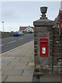
Kirkwall: postbox № KW15 18, Mount Drive
This Elizabeth II-reign postbox is set into an ornate pillar on the corner of Mount Drive and the unnamed coast road. It is emptied finally at 2:15pm on weekdays and 45 minutes earlier on Saturdays.
Image: © Chris Downer
Taken: 25 Jul 2011
0.24 miles
2
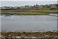
Cromwell Road
Cromwell road runs alongside the east basin of the harbour.
Image: © Anne Burgess
Taken: 13 Jun 2018
0.24 miles
3
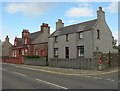
Kirkwall houses
These houses are on the northern outskirts of Kirkwall, facing the sea.
Image: © Rob Burke
Taken: 18 May 2006
0.24 miles
4

The Bay of Kirkwall
Most of the harbour is to the left, but the deep sea part is on the far side opposite.
Image: © Bill Boaden
Taken: 29 Jul 2013
0.25 miles